What Have We Done for You Lately?

We at the MIC are transportation planners. We lay the groundwork for projects that use federal tax dollars.

Large, public, tax-funded infrastructure requires a huge investment of federal, state and local funds—but then, our region’s mobility, quality of life, economic growth and competitiveness rely on the transportation network. Every household and business depends on safe, multi-modal transportation infrastructure for moving people and goods.

Local input,  coordination, and planning expertise

Our job is to coordinate with all local jurisdictions so the money for this infrastructure is well-spent and reflects local priorities.

We at the MIC are also elected officials. Our Board members represent all local units of government in the Duluth-Superior area—states, counties, cities and townships. Because these neighboring jurisdictions all have responsibilities and make decisions that impact the transportation system, coordination is key to making efficient use of limited financial resources.

And the term “stakeholder” is the real deal for us – figuring out and working with those who have a vested interest in the decisions that get made. Our job is to work with the right people – planners, engineers, local officials – to set joint priorities for funding projects, agree on timelines, and to share information about the projects we’re up to.

Bottom-up planning process

This kind of cooperative process is what Metropolitan Planning Organizations (MPOs) like the MIC are designed to do, here and across the country. We facilitate a bottom-up approach to transportation planning, allowing for local input into decisions how federal funds are spent, instead of a top-down approach that would make decisions about local projects and priorities at the federal or state level.

Planning Successes

Most important, this planning process is getting real results in our area. Here are some of our planning successes:

HTAC: a national model

Our Harbor Technical Advisory Committee, or HTAC, is recognized as a national model for doing just that—getting the right people in the room to solve problems. The HTAC is a nationally-recognized, bi-state forum to discuss issues confronting the Ports of Duluth and Superior. The HTAC brings together a broad range of industry, environmental and government stakeholders to provide sound planning and management recommendations and to promote the harbor’s economic and environmental importance to our community.

Erie Pier Management Plan: first of its kind on the Great Lakes

HTAC stakeholders have worked for many years to craft the Erie Pier Management Plan, a blueprint for transitioning the Erie Pier Confined Disposal Facility (CDF) to a first-of-its kind Processing and Reuse Facility (PRF). By creating a cost effective and environmentally sound alternative to current dredge material disposal practices for Great Lakes ports, this innovative Plan will save local taxpayers the millions of dollars it would have cost to develop a new CDF.

Landside Port Access Study: targeted roadway construction

The Landside Port Access Study was used to educate the public and policy makers about the land-based access needs of the Port and laid the foundation for funding a new roadway project (Helberg Drive) to improve access and safety.

Corridor planning: addressing problems before they arise

The MIC’s Corridor Planning initiatives seek to be proactive, by identifying and addressing problems along local roadways before they arise. They balance mobility needs with adjoining land uses and environmental and community interests.

Our North 28th Street Plan identified and made recommendations to alleviate critical transportation issues on North 28th Street, in Superior, in advance of planned road reconstruction. Significant safety concerns needed to be addressed due to several conflicting land uses, including the construction of three new schools, a skate park, a recreational trail, housing units and a newly-developed commercial area.

The Duluth Heights Traffic Circulation Study was undertaken at the request of neighbors and local elected officials to address the issue of residential streets being used as an unwelcome and unintended thoroughfare to a commercial district. Using an extensive public participation process, MIC staff worked closely with residents to document the level of cut-through traffic, and identify options to reduce impacts and improve flow in and around the neighborhood.

This planning process set the groundwork for the City to pursue funding for a new roadway connection (Joshua Avenue) between the Miller Hill commercial district and the east side of Duluth.

Long Range Planning: coordinated goals and strategies

The MIC’s Long Range Planning initiatives provide policy guidance, goals and coordinated strategies for jurisdictions within the greater metropolitan area of Duluth, MN and Superior, WI.

Directions 2035 is our Long Range Transportation Plan, setting forth a vision for the area-wide transportation network for the next 25 years. The LRTP provides a framework for working cooperatively to provide a well-maintained, integrated, accessible and multi-modal transportation system to safely and efficiently move people and freight, within the constraints of funding the region can reasonably expect to receive.

The Duluth Urban Area Growth Impact Study examines how best to accommodate growth in areas outside the urban services boundary while ensuring taxpayer protection from the consequences of inefficient patterns of development. Future land use information from each jurisdiction was used as part of a regional planning process to examine growth impacts and to identify the specific areas best suited for development.

Bike, Pedestrian and Transit Planning: mobility and quality of life

The MIC’s planning initiatives for modes of travel that are not centered on cars and trucks account annually for about 20% of our work program and budget. They are important because they aim to improve access, mobility and quality of life for all people in our area, regardless of age or physical ability, whether they travel by car, bike, bus or on foot.

The MIC’s Bicycle and Pedestrian Advisory Committee (BPAC) engages local stakeholders to provide sound planning recommendations and to provide public outreach and education about bike- and pedestrian-related plans and projects.

The Duluth-Superior Area Bike Map is our most popular product, an award-winning guide to the best on- and off-street bike routes in and through this region.

The Duluth Sidewalk Study provides technical and policy guidance to assist local elected officials in working with neighborhoods during roadway reconstruction projects. The GIS-based interactive map is a powerful tool for decision makers to apply data to the sometimes-contentious discussions about locating sidewalks on local streets.

Safe Routes to School (SRTS) Plans: The MIC was an early proponent of SRTS planning, working closely with many community stakeholders collecting data, conducting field observations and identifying safety issues around schools. The MIC’s recommendations have been incorporated into many funded projects to improve bike and pedestrian access to schools in the cities of Duluth, Superior and Proctor.

Transit Planning: The MIC provides ongoing input and technical assistance on local transit initiatives including planning and securing funding for a future downtown multimodal facility. Results from a recent ridership survey will be utilized by MnDOT to determine the potential for utilizing transit service to mitigate the effects of major construction projects statewide.

This is where you come in

Hopefully this gives you an idea of how we have worked (for nearly forty years!) to ensure that federally-funded infrastructure investments are developed with input from the people who know this area best.  As a local resident, do our planning initiatives reflect your priorities?

How to Get From Here to There: Access and Connectivity in the Lincoln Park Neighborhood

Transformative changes are taking place in the Lincoln Park neighborhood.

View from the new Western Middle School
Looking down from the new Western Middle School site to the new Clyde Iron recreational facility (lower left)

A major redevelopment of the old Clyde Iron industrial complex was just completed. A new Western middle school is rising on the hillside. A segment of the Cross-City trail will be winding through this neighborhood in the next few years as it spans the city from east to west along the waterfront.

Here at the MIC, we see these exciting new community-oriented developments and start to think about…access, connectivity and land use.

We’re kind of geeky that way.  Let me explain.

Access is about making sure that people, who have different mobility options and who need or want to use these facilities, can get to them easily and safely.

Connectivity is about making sure that usable and intuitive transportation links exist between the new developments and other destinations.  At the base of this this neighborhood, popular destinations would include Wade Stadium, Wheeler Field and Harrison Park.  And along the top of the ridgeline are Skyline Parkway and the Superior Hiking Trail.

Complicating the situation, the land uses for these facilities are distinctly at odds with each other.

The middle school is located on the edge of a traditional residential neighborhood that is easy to walk through, with square blocks, houses close together and minimal, slow moving traffic. It can actually be characterized as a semi-rural area, with few sidewalks and narrow streets, many of which dead end into large open spaces.

The Clyde Iron complex, in contrast, which also houses a Boys and Girls Club, indoor athletic fields, year-round ice rink, and in the future a nearby Duluth Children’s Museum—is located in an established industrial area, where a significant level of pedestrian traffic was not anticipated.

Last but not least is the huge barrier of the railroad tracks that run between the school and the Wheeler Field park space and the Denfeld neighborhood immediately west of the school.

So, a number of our current studies are taking a look at how people move around this neighborhood in light of the new developments.  Creating a walking corridor between these facilities is a key transportation piece for this neighborhood.

The Lincoln Park Pedestrian Corridor Plan is focused on creating a walking route up and down the hill from the middle school to the Clyde Iron complex.

An upcoming Safe Routes to School site assessment will further examine the school and walking and bicycling routes to the middle school to the surrounding neighborhoods.

And a larger neighborhood wide transportation study, the Lincoln Park Multimodal Transportation Assessment will build off of the other 2 studies and focus on all modes of travel in the neighborhood.

Lots of work is ahead.  We’ll keep you posted.

Photo credit: Scott Byykkonen

Co-writing credit: Rondi Watson

Transportation Funding: From Neutral Ground to Battleground

Visible damage to deck of I-35 in Duluth, MN


As I discussed in an earlier post, there’s a growing local and national backlog of critical transportation infrastructure projects—with no funding in sight.

Consensus Actually Exists

You might be interested to know that all branches of the federal government, from both sides of the isle, agree that we are not investing properly now for the transportation needs of the future.

To put this in perspective, the U.S. is spending approximately 4 to 5 times less on infrastructure than other countries are, including developing nations like China and India.

Since our interstate highway system was built in the 1960s, government expenditures on infrastructure have fallen to just 2.4 percent of GDP. In contrast Europe invests 5 percent of its GDP on infrastructure and China 9 percent.

Pothole as an example of transportation infrastructure that needs funding to maintainAs a result, the United States Is now ranked twenty-third overall for infrastructure quality, between Spain and Chile.

Political Will Does Not

Not so long ago, spending tax dollars on infrastructure was not nearly so political and divisive as it is today.  Roads, bridges and railways used to be neutral ground on which the parties could come together to support the country’s growth. In 1991, the federal transportation bill (the Intermodal Surface Transportation Efficiency Act, termed ISTEA for short), passed both branches of Congress by nearly a 5 to 1 margin.

Fast forward twenty years.

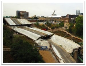
I-35 bridge collapse in Minneapolis, MN, Today’s gridlock in Washington has resulted in years of legislative limbo.  Transportation funding has been limping along under a series of short-term extensions and appropriations because Congress can’t agree on what should be included in the new transportation bill—and hasn’t figured out how to pay for them either.

The consequences of this inaction are severe. Crumbling bridges and roadways and increased congestion will not only be expensive problems to solve in the future, but will also have a cost in the increased amount of time we spend on substandard roads.

Our nation’s economic future relies on its ability to deliver goods and services, a task that is increasingly more difficult as our highway system falls into disrepair. Without action, our nation’s economic competitiveness will diminish.

While the urgency of the problem is plain to all – the political will to fix it isn’t there.

It Will Get Personal

And the hard part is, it’s not just our politicians who will need to make some attitude adjustments.  All of us, as users of the transportation network, will need to be willing to make a shift in how we think about paying our way.

Mileage-based fees, not motor fuel taxes, are the fairest way to assess the costs and benefits to the users of the system.  BUT…

Solutions Exist

There are many options, ideas and technologies available to us to pay for the transportation system we need, now and into the future.

But they will take some getting used to.  I’ll talk about them in my next blog post.  Stay tuned.

Pothole photo credit: David Erickson
 
 
I-35 photo credit: Marion Doss
 

Roads, Trails, or Both?

Priorities for Duluth’s Transportation System

As discussed in our previous blog, approximately $45 million in federal funds are being programmed for Duluth area transportation projects for 2012-2015.

The draft Transportation Improvement Program (TIP) spells out costs and timeframes for a total of 36 high-priority projects over four years and is now open for public comment.

Balancing the needs of all users

It seems we easily divide ourselves into those who drive versus those who ride the bus versus those who bike and so forth….an “us versus them” scenario.

Well, in reality the transportation system—and the public spaces they are a part of—are used by people in a much more complex way. You might drive to your job or to shop, but there will always be some amount of walking involved, from car to final destination and back again. You might use the sidewalks for walking from place to place, but also for stopping to talk to your neighbor in a common space. You might ride your bike down the big hill but put it on a DTA bus for the trip back up.

Looking through this lens, from the perspective of the users of the transportation system, you can see how this TIP has a major focus on how to really connect people in the safest and most efficient way possible. 

Continuing to fix the highways

Preservation work on the two major bridges is needed to refurbish the Blatnik (I-535) in 2012 and the Bong (US Highway 2) in 2014. These TIP projects not only have the highest price tags and but also will receive the most attention—yes, just when the I-35 reconstruction “megaproject” is finished, there will be several more years of high-profile road construction projects, on the bridges this time!

Improvements for those who walk, bike, or take the bus

While the highway projects are devoted solely to cars and trucks, funding is also included to provide a safe alternative to driving.  A paved pedestrian and bicycle pathway, running parallel to I-35, will connect the whole city from west  to east. The Munger Trail will eventually extend all the way to the Lakewalk by constructing short segments of a new Cross-City Trail each year. The popular Duluth Lakewalk will in turn be extended from 60th Avenue East to Highway 61, and then out to Brighton Beach up the north shore.

Funding for the Duluth Transit Authority will purchase new buses and provide operating support for both its regular route and STRIDE bus service.

And thanks to recent Complete Streets efforts in Duluth, local street projects will take into account how the roads are being used by people every day and will be designed accordingly.

The projects funded in the draft 2012-2015 Duluth area TIP balance the need to move vehicles efficiently with the needs of all people who use these public spaces, including those who utilize public transportation, those who traverse the roads by bicycle and those who are on foot.

Which makes sense to us – what do you think?

Detour Ahead: Find Out Exactly Which Streets You’ll Have to Avoid This Construction Season

Congratulations, you have survived another winter in Duluth-Superior!

Coming soon…the construction season.

Work has already resumed on the I-35 Mega Project, but many other city, county, and state projects are scheduled for the Duluth-Superior area this year, including:

  • Midway Road (U.S. Hwy 2 – MN HWY 194)
  • West Skyline Parkway around Enger Park
  • 21st Avenue East;
  • Arrowhead Road from Kenwood to Rice Lake Road
  • Martin Road from Howard Gnesen Road to Rice Lake Road
  • U.S. Hwy 2/Belknap Street from Hill Avenue to East 2nd Street

Click on the “plus” sign on the map, below, to zoom in and then click on the traffic cones for details about specific projects:

View Larger Map

Give it a try and tell us what you think.