The INTERNal Outsider: Adventures in Excel

An Intern’s-Eye View of the MIC


Bikes, peds…

Did you realize that on just fourteen streets in Duluth and Superior during one 12-hour period in September, there are around 1,240 uses of infrastructure by bicyclists, and 5,896 uses of infrastructure by pedestrians? The entire town I live in (around 900 people) would have to walk back and forth more than six times to get that pedestrian count.

I am going to guess that your answer is no, you had no idea the extent of the infrastructure used by alternative transportation in Duluth and Superior.

I’m also guessing that most of you also don’t know the extent of the effort that goes into this 5×19-cell table.BP Count Spreadsheet-314px

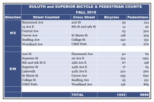
This is the fourth year of the biannual bicycle and pedestrian counts. James Gittemeier, senior planner at the MIC, and Shawna Mullen-Eardley of the Healthy Duluth Area Coalition determine count data sites, recruit and coordinate volunteers, and lead volunteer training. After attending training, each volunteer* is asked to sit for two hours at a count site and fill out a form noting direction of travel, users by demographic (male, female, child, using assistive device), and mode of transportation (walking, biking, “other”). (The method for the count was created by the National Bicycle and Pedestrian Documentation Project).

Are you getting a better idea of what goes into this seemingly simple chart?

After the day is over and all of the forms are gathered, the amazingly talented and intelligent intern (hey that’s me!) gets to decipher the notes of dozens of volunteers. The data gets entered into Excel by 15 minute increments for each demographic and each mode of transportation. Lucky for me, there is already an Excel spreadsheet that is set up to create the totals. I then finagle Excel to make those totals magically appear into this chart.

Don’t think this chart is the final product, either! After the data is entered and the totals are gathered, we begin an analysis of how the trends in the data will have an effect on future decision making for alternative transportation infrastructure. Excel is very useful in the analysis portion. So far I’ve created around 50 charts to get a better idea of visible trends.

Although I will concede that the data is not perfect – human error in counting and entering the data – the numbers tell an interesting story: The people of Duluth and Superior are outside and active.

*A huge thank you to all volunteers whether you did more than asked or did just as much as you could

…and buses (oh my!)

I can’t talk about all the time I’ve spent in Excel the last two weeks without also bringing buses into the mix.

Robert Herling, my supervisor and another senior planner at the MIC, has been researching the infrastructure use in the Lincoln Park for the Multi-modal Study that’s underway for that neighborhood.

One important aspect of this research is looking into the use of public transit.Garfield bus stop bus in sight-175px

Have you ever had to transfer between two city buses to find that either the last one left just minutes prior to your arrival, or you have less than five minutes to get to the bus stop on the other side of an intersection? You should try it some time.

Robert tasked me with finding out how often this occurs for a few of the major transfers in the Lincoln Park area, from the mainline at 21st Ave W and Superior Street to the mall lines, as well as the mainline at Superior Street and Garfield to the Superior, Wisconsin line. A misstep in scheduling is not a rare occurrence for these bus users, but don’t fret! Our loyal transit authorities are not overlooking this issue.

Thanks for taking the time to join me on my journey to find out what the MIC is all about. Now I must get back to my spreadsheets.

What will our Transportation System Look Like in 2040?

Updating the 25-year Vision for Transportation in the Twin Ports

Mode Horizontal Image Strip-530px


You are invited to attend one of the four public meetings on Connections 2040 – the Twin Ports Long Range Transportation Plan.


The Duluth-Superior Metropolitan Interstate Council (MIC) is updating its Long Range Transportation Plan (LRTP) to provide policy guidance, goals and strategies for jurisdictions within the greater metropolitan area of Duluth, Minnesota and Superior, Wisconsin.  It covers a twenty-five year planning horizon and is updated every four years.Connections2040-logo-320px

The over-arching purpose of the LRTP is to provide a planning foundation for jurisdictions to work cooperatively to provide a well-maintained, integrated, accessible and multi-modal transportation system to safely and efficiently move people and freight for the next 25 years, within the constraints of funding the region can reasonably expect to receive.

The heart of the Plan is a listing of proposed federally-funded transportation projects, as well as transportation initiatives underway within the region, to be implemented from 2015-2040. You can view an interactive map of the projects here.

To learn more about demographic trends for this area, projections, transportation priorities and planned projects, you have three opportunities for input:

1. Attend a Public Meeting

Thurs. Sept 11, 2014
5:00-7:00pm
Community Action Duluth, 2424 W 5th Street, Duluth, MN 55806

Thurs. Sept 18, 2014
4:00-6:00pm
Superior Public Library, 1530 Tower Avenue, Superior, WI 54880

Thurs. Sept 25, 2014
4:00-6:00pm
Arrowhead Regional Development Commission (ARDC)
221 W First Street, Duluth, MN 55802

Mon. Sept 29, 2014
4:00-7:00pm (drop-in)
214 West Superior Street
221 W First Street, Duluth, MN 55802

2.  Visit our Connections 2040 web page at www.dsmic.org/lrtp for more information about the plan and to view the interactive map of proposed projects.  You can use the “layers” tab in the upper right corner to toggle on and off views of information about environmentally sensitive areas, low-income and minority populations, etc.

3.  Contact MIC Senior Planner James Gittemeier by phone at (218) 529-7556 or by email at jgittemeier@ardc.org.


Lincoln Park Multimodal Study (2016)-2

This plan identifies issues and makes recommendations to improve safety and connectivity for all modes of transportation in the Lincoln Park neighborhood of Duluth, Minnesota.

Click to view plan

Complete document (75 MB)


Click to view document

Executive Summary (95 kb)


Document is presented here in sections (to reduce PDF size):

Click to view doument

Part 1 (10 MB / 22 pp)
Summary / Table of Contents /
Introduction / Stakeholder Involvement


Click to view document

Part 2 (19 MB / 38 pp)
Land Uses / Demographics /
Growth Scenarios / Road Network


Click to view document

Part 3 (22 MB / 27 pp)
Freight Network / Transit System


Click to view document

Part 4 / (10 MB / 32 pp)
Active Transportation–Bicyclists and Pedestrians /
Multimodal Integration / Safety


Click to view document

Part 5 (18 MB / 29 pp)
Recommendations and Appendix

Carless in Duluth

It’s no secret that we Americans are in love with our cars.

They demonstrate our status and standing in society.

The way we’ve invested in roads and highways and the way we’ve developed our cities pretty much mandates that you need to own a car to be able to access jobs, food, education and recreation.

Driving a car has become the default mode of travel for almost all people for every trip of any distance.

And here in Duluth, perched on a steep hill with prominent winters, it makes sense that people want to drive.

So why would a person choose not to?

Video documentary and panel discussion

Carless in Duluth, a video documentary about people who walk, bike, or take the bus instead of driving, will premiere on:

Tuesday, March 20, 2012
6:00 pm
Teatro Zuccone
222 East Superior Street, downtown Duluth

Following the video, there will be a panel discussion with engineers, planners, and other experts in the area.  Afterward, an informational tabling session will be held in the atrium where food and drinks will also be available.

Area bike and ped projects, and lots of them

The event, hosted by the Healthy Duluth Area Coalition, follows a series of public meetings that were hosted throughout Duluth about one month ago.  At each meeting, residents were given the opportunity to learn about ongoing and upcoming bicycle and pedestrian projects happening all over the city, including the Cross-City Trail, the Duluth Citywide Sidewalk Study, and the Duluth Traverse Mountain Bike Trail, and gave their feedback about their interest in these projects as well as other potential ideas. Over 50 residents participated in these meetings.

The Carless in Duluth premiere and transportation forum on March 20th will conclude this series of public outreach events. Organizations including the Duluth Transit Authority, the Metropolitan Interstate Council, City of Duluth Engineering, and the Bike Cave Collective have already confirmed their participation in this event, with pending confirmation from the Northern Lights Express, COGGS, and the UMD Cycling Club.

Check it out – it’s free and open to the public.

Duluth Sidewalk Study

Elderly Pedestrians walking along shoulder of busy road in Duluth, MN

Why do sidewalks matter?

Did you know that it’s estimated that up to 40% of the U.S. population does not drive? This includes children, of course, but also people who are disabled, elderly or choose not to drive. Sidewalks, not roads, are the main transportation facility for a big chunk of our community.

We’ve all seen people walking in the roads, but it’s not hard to see that sidewalks provide a preferable space for pedestrian travel than using the street. Take a close look at the picture for this post – it’s one that we took several years ago of an elderly couple making a perilous winter journey (presumably out of necessity) along the shoulder of Central Entrance near Miller Hill Mall, Duluth’s main commercial district.

Besides providing a safe passageway for all to use, investing in sidewalks—infrastructure that promotes walking—has many benefits spread widely across the community.

Health

It’s not news that an increasing portion of the population, including many children, lack regular physical exercise. And walking is one of the most practical ways to increase physical activity among a broad population.

Health experts believe that more balanced transportation systems can contribute to improved personal and community health not only because they accommodate and encourage active transportation, but also because they provide opportunities for increased social interaction and, with more “eyes on the street” can reduce crime.

Wealth

A good sidewalk network, by providing “walkable” infrastructure, is strongly linked to a community’s economic vitality. According to the Seattle Department of Transportation, “walkable neighborhoods typically have active streets that promote commercial exchange, while providing safe and efficient ways for residents to travel on foot.”

Green

Sidewalks can also promote less reliance on automobiles, when walking is an option for shorter trips.

Equitable

Walking tends to be particularly important for elderly, disabled and lower-income people who have few opportunities to participate in sports or formal exercise programs and more limited transportation options.

And most trips that anyone makes have a walking component, whether it is between a parking spot and a final destination or to and from a transit stop.

That’s Where We Come In

The MIC has been working with the City of Duluth and area stakeholders on a two-phase study of Duluth sidewalks. In today’s financial climate, resources for sidewalk maintenance and development are limited. Good information is needed to utilize those scare resources efficiently. A number of citizen groups in the Duluth area, as well as city administration, have requested that sidewalk information be developed to assist with making targeted decisions about sidewalk improvements. The results of this analysis will be used to determine future capital improvements for sidewalk development, preservation, snow removal and maintenance.

The first phase—the sidewalk inventory—has been underway since last spring to develop an accurate inventory of where sidewalks are located and what condition they are in. When it’s complete, this information will be presented as a searchable GIS tool.

The second phase of the study—priority pedestrian modeling¬ will identify which sidewalks are the most heavily used, based on pedestrian generators such as schools, retail areas and transit stops. Other information considered in the model includes population density, poverty rates and transit ridership.

So, what do you think?

Negotiations on the new federal transportation bill may eliminate funding for bike and pedestrian infrastructure and dedicate it to the construction of roads and bridges only. Are sidewalks part of your personal transportation network? What ones around town do you use, or present obstacles?

Co-writing credit: Rondi Watson