Duluth-Superior’s Harbor Technical Advisory Committee: A Model for Successful Stakeholder Participation & Coordination

Aerial view of the Ports of Duluth-Superior “A committee that actually gets work done”

The HTAC is a working group for addressing challenges and opportunities in the Duluth-Superior harbor, while promoting the port’s economic and environmental importance to both communities.

It is one of three advisory committees to the Metropolitan Interstate Council (MIC), the federally designated Metropolitan Planning Organization (MPO) for the Duluth-Superior urbanized area.

And it is unique–the only stakeholder group of its kind in the country.

More important, it is, in the words of former Duluth Seaway Port Authority Director Adolf Ojard, “a committee that actually gets work done.”

Complexity, Controversy and Collaboration

Port-centered issues are usually complex, often controversial and sometimes downright contentious: dredged material management; marine safety; port security; land and recreational uses; economic development proposals; accelerated corrosion of maritime infrastructure; ballast water and invasive species management; legacy environmental degradation and habitat restoration initiatives –to name a few.

None of these problems affects one group alone, and none can be addressed except through the coordinated action of many diverse organizations and individuals. The HTAC has emerged as a national model for doing just that, through planning, collaboration, information sharing and long-term institutional involvement.

Its diverse members all hold a stake in the continued success and health of the harbor. Participation on the HTAC encourages representatives from industry, government, academic, environmental, regulatory and citizen groups on both sides of the bridge to recognize that although they have distinct missions they also have shared goals.

HTAC members, in other words, are genuine stakeholders who have, over its 20-year history, learned the value of playing nice and working hard together.

Result: a new paradigm for dredge material handling

Aerial view of Erie Pier re-engineered as a PRFOne recent example of the HTAC’s successful, collaborative planning process is what’s happening at Erie Pier. It might seem a little hard to get excited about this “hidden in plain sight” facility on the Duluth waterfront—but it represents an entirely new paradigm for dredge material handling.

Thanks to the efforts of many HTAC members who undertook an intensive multi-year planning process, and to the US Army Corps of Engineers which subsequently agreed to make a significant investment in redesigning and re-engineering the facility, a major physical restructuring of the full-to-capacity Contained Disposal Facility at Erie Pier was undertaken to convert it to a Recycle-Reuse Facility.  It utilizes hydraulic sorting to separate out the clean, uncontaminated sand and silt that’s dredged from the shipping channels for reuse in large-scale projects such as road construction and landfill cover.

The Duluth Seaway Port Authority now manages Erie Pier dredge materials as a valuable, re-usable resource instead of a waste product.  By creating a cost effective and environmentally sound alternative to standard dredge material disposal practices, it will save local taxpayers the millions of dollars it would have cost to develop a new CDF.

Sincerest form of flattery

It also has the potential to change the way other Great Lakes ports manage their dredging operations.  Erie Pier has recently gained the attention of the Canadian federal government, which is looking at the Erie Pier facility as a model for a new hydraulic sorting procedure at one or more of their dredging sites.

Most port communities face similar challenges.  For this reason, we’ve been invited to present the HTAC model at many national-level planning and port conferences in recent years.

More Information/Get Involved

You can follow or participate in this notable initiative that’s happening right here in Duluth-Superior.  For more information or to get on our meeting mailing list, check out the HTAC page on the MIC website at dsmic.org/htac.

Writing credit: Andy McDonald contributed to this article.

Photo credits:
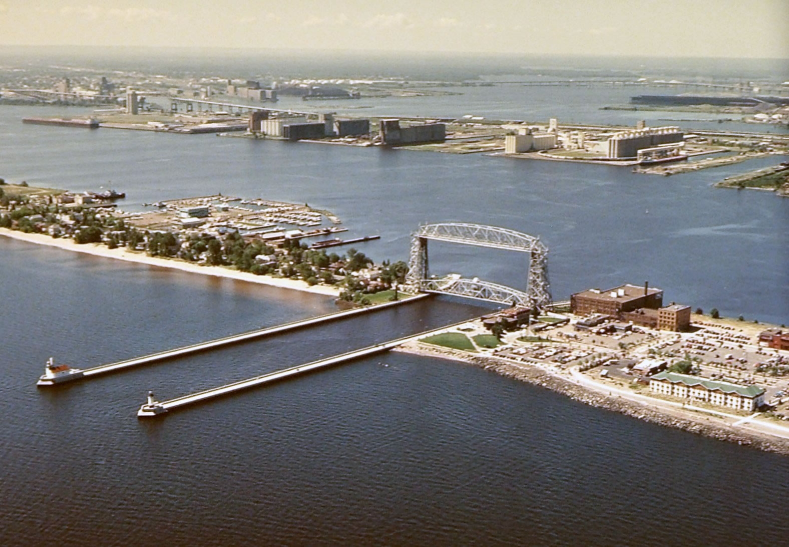
Duluth-Superior Harbor aerial view – Gary Lidholm, USDA Forest Service, Superior National Forest

Erie Pier aerial view – Google Earth 2010

What Have We Done for You Lately?

We at the MIC are transportation planners. We lay the groundwork for projects that use federal tax dollars.

Large, public, tax-funded infrastructure requires a huge investment of federal, state and local funds—but then, our region’s mobility, quality of life, economic growth and competitiveness rely on the transportation network. Every household and business depends on safe, multi-modal transportation infrastructure for moving people and goods.

Local input,  coordination, and planning expertise

Our job is to coordinate with all local jurisdictions so the money for this infrastructure is well-spent and reflects local priorities.

We at the MIC are also elected officials. Our Board members represent all local units of government in the Duluth-Superior area—states, counties, cities and townships. Because these neighboring jurisdictions all have responsibilities and make decisions that impact the transportation system, coordination is key to making efficient use of limited financial resources.

And the term “stakeholder” is the real deal for us – figuring out and working with those who have a vested interest in the decisions that get made. Our job is to work with the right people – planners, engineers, local officials – to set joint priorities for funding projects, agree on timelines, and to share information about the projects we’re up to.

Bottom-up planning process

This kind of cooperative process is what Metropolitan Planning Organizations (MPOs) like the MIC are designed to do, here and across the country. We facilitate a bottom-up approach to transportation planning, allowing for local input into decisions how federal funds are spent, instead of a top-down approach that would make decisions about local projects and priorities at the federal or state level.

Planning Successes

Most important, this planning process is getting real results in our area. Here are some of our planning successes:

HTAC: a national model

Our Harbor Technical Advisory Committee, or HTAC, is recognized as a national model for doing just that—getting the right people in the room to solve problems. The HTAC is a nationally-recognized, bi-state forum to discuss issues confronting the Ports of Duluth and Superior. The HTAC brings together a broad range of industry, environmental and government stakeholders to provide sound planning and management recommendations and to promote the harbor’s economic and environmental importance to our community.

Erie Pier Management Plan: first of its kind on the Great Lakes

HTAC stakeholders have worked for many years to craft the Erie Pier Management Plan, a blueprint for transitioning the Erie Pier Confined Disposal Facility (CDF) to a first-of-its kind Processing and Reuse Facility (PRF). By creating a cost effective and environmentally sound alternative to current dredge material disposal practices for Great Lakes ports, this innovative Plan will save local taxpayers the millions of dollars it would have cost to develop a new CDF.

Landside Port Access Study: targeted roadway construction

The Landside Port Access Study was used to educate the public and policy makers about the land-based access needs of the Port and laid the foundation for funding a new roadway project (Helberg Drive) to improve access and safety.

Corridor planning: addressing problems before they arise

The MIC’s Corridor Planning initiatives seek to be proactive, by identifying and addressing problems along local roadways before they arise. They balance mobility needs with adjoining land uses and environmental and community interests.

Our North 28th Street Plan identified and made recommendations to alleviate critical transportation issues on North 28th Street, in Superior, in advance of planned road reconstruction. Significant safety concerns needed to be addressed due to several conflicting land uses, including the construction of three new schools, a skate park, a recreational trail, housing units and a newly-developed commercial area.

The Duluth Heights Traffic Circulation Study was undertaken at the request of neighbors and local elected officials to address the issue of residential streets being used as an unwelcome and unintended thoroughfare to a commercial district. Using an extensive public participation process, MIC staff worked closely with residents to document the level of cut-through traffic, and identify options to reduce impacts and improve flow in and around the neighborhood.

This planning process set the groundwork for the City to pursue funding for a new roadway connection (Joshua Avenue) between the Miller Hill commercial district and the east side of Duluth.

Long Range Planning: coordinated goals and strategies

The MIC’s Long Range Planning initiatives provide policy guidance, goals and coordinated strategies for jurisdictions within the greater metropolitan area of Duluth, MN and Superior, WI.

Directions 2035 is our Long Range Transportation Plan, setting forth a vision for the area-wide transportation network for the next 25 years. The LRTP provides a framework for working cooperatively to provide a well-maintained, integrated, accessible and multi-modal transportation system to safely and efficiently move people and freight, within the constraints of funding the region can reasonably expect to receive.

The Duluth Urban Area Growth Impact Study examines how best to accommodate growth in areas outside the urban services boundary while ensuring taxpayer protection from the consequences of inefficient patterns of development. Future land use information from each jurisdiction was used as part of a regional planning process to examine growth impacts and to identify the specific areas best suited for development.

Bike, Pedestrian and Transit Planning: mobility and quality of life

The MIC’s planning initiatives for modes of travel that are not centered on cars and trucks account annually for about 20% of our work program and budget. They are important because they aim to improve access, mobility and quality of life for all people in our area, regardless of age or physical ability, whether they travel by car, bike, bus or on foot.

The MIC’s Bicycle and Pedestrian Advisory Committee (BPAC) engages local stakeholders to provide sound planning recommendations and to provide public outreach and education about bike- and pedestrian-related plans and projects.

The Duluth-Superior Area Bike Map is our most popular product, an award-winning guide to the best on- and off-street bike routes in and through this region.

The Duluth Sidewalk Study provides technical and policy guidance to assist local elected officials in working with neighborhoods during roadway reconstruction projects. The GIS-based interactive map is a powerful tool for decision makers to apply data to the sometimes-contentious discussions about locating sidewalks on local streets.

Safe Routes to School (SRTS) Plans: The MIC was an early proponent of SRTS planning, working closely with many community stakeholders collecting data, conducting field observations and identifying safety issues around schools. The MIC’s recommendations have been incorporated into many funded projects to improve bike and pedestrian access to schools in the cities of Duluth, Superior and Proctor.

Transit Planning: The MIC provides ongoing input and technical assistance on local transit initiatives including planning and securing funding for a future downtown multimodal facility. Results from a recent ridership survey will be utilized by MnDOT to determine the potential for utilizing transit service to mitigate the effects of major construction projects statewide.

This is where you come in

Hopefully this gives you an idea of how we have worked (for nearly forty years!) to ensure that federally-funded infrastructure investments are developed with input from the people who know this area best.  As a local resident, do our planning initiatives reflect your priorities?

How to Get From Here to There: Access and Connectivity in the Lincoln Park Neighborhood

Transformative changes are taking place in the Lincoln Park neighborhood.

View from the new Western Middle School
Looking down from the new Western Middle School site to the new Clyde Iron recreational facility (lower left)

A major redevelopment of the old Clyde Iron industrial complex was just completed. A new Western middle school is rising on the hillside. A segment of the Cross-City trail will be winding through this neighborhood in the next few years as it spans the city from east to west along the waterfront.

Here at the MIC, we see these exciting new community-oriented developments and start to think about…access, connectivity and land use.

We’re kind of geeky that way.  Let me explain.

Access is about making sure that people, who have different mobility options and who need or want to use these facilities, can get to them easily and safely.

Connectivity is about making sure that usable and intuitive transportation links exist between the new developments and other destinations.  At the base of this this neighborhood, popular destinations would include Wade Stadium, Wheeler Field and Harrison Park.  And along the top of the ridgeline are Skyline Parkway and the Superior Hiking Trail.

Complicating the situation, the land uses for these facilities are distinctly at odds with each other.

The middle school is located on the edge of a traditional residential neighborhood that is easy to walk through, with square blocks, houses close together and minimal, slow moving traffic. It can actually be characterized as a semi-rural area, with few sidewalks and narrow streets, many of which dead end into large open spaces.

The Clyde Iron complex, in contrast, which also houses a Boys and Girls Club, indoor athletic fields, year-round ice rink, and in the future a nearby Duluth Children’s Museum—is located in an established industrial area, where a significant level of pedestrian traffic was not anticipated.

Last but not least is the huge barrier of the railroad tracks that run between the school and the Wheeler Field park space and the Denfeld neighborhood immediately west of the school.

So, a number of our current studies are taking a look at how people move around this neighborhood in light of the new developments.  Creating a walking corridor between these facilities is a key transportation piece for this neighborhood.

The Lincoln Park Pedestrian Corridor Plan is focused on creating a walking route up and down the hill from the middle school to the Clyde Iron complex.

An upcoming Safe Routes to School site assessment will further examine the school and walking and bicycling routes to the middle school to the surrounding neighborhoods.

And a larger neighborhood wide transportation study, the Lincoln Park Multimodal Transportation Assessment will build off of the other 2 studies and focus on all modes of travel in the neighborhood.

Lots of work is ahead.  We’ll keep you posted.

Photo credit: Scott Byykkonen

Co-writing credit: Rondi Watson

My Awesome Walk to Work

Snow-covered section of the Superior Hiking Trail in Duluth MN

My Facebook post today reads: “Another awesome walk to work this morning on the Superior Hiking Trail—despite the snow—or maybe because of it!”

Within seconds a friend (an actual friend, in this case) responded “I did the same. I love Chester Park.”

Another commented “You are the luckiest commuter ever!”

This exchange reminded me of the simple, real-life benefits of one of our favorite concepts here at the MIC: multi-modal transportation networks.

It’s all about options

From a transportation planning perspective, a multi-modal transportation network refers to a balance of  infrastructure that supports multiple modes of travel — a mix of roads, air, marine/port, rail, public transportation, bicycle and pedestrian facilities (including paved and non-paved trails).  This mix is plainly visible on any given day in the Duluth-Superior area.

From a societal and governmental perspective, multi-modal transportation networks have been widely supported because a balanced transportation system encourages economic growth, reduces congestion and environmental impacts, and improves mobility and access to transportation.

From my personal perspective, though, a multi-modal transportation network means that I have options. It was just too nice of a morning to get in my car and drive (the very walkable distance of) two and a half miles.

Trails as commuter pathways

One big advantage of living in Duluth, Minnesota, is the proximity of urban areas to green spaces. A multi-modal system, in this city, means that I can walk out my back door onto the Superior Hiking Trail, which in turn intersects with our urban streets infrastructure across Skyline Parkway (as scenic a walk as you could ask for), down through a couple of local neighborhoods and to our downtown office.

And a community-wide vision is emerging for Duluth to become the premier trail city in North America. Developing an inter-connected trails system will provide not just outstanding recreational opportunities but compelling transportation options as well.

Quality of life improvement

Bottom line, I don’t have to get in my car and drive every time I need to go somewhere. I’m able to travel on foot (or by bike or by bus), and I consider that a big quality of life enhancement.

How about you?

Do you have an awesome walk to work of your own?  Would you like to be able to walk or bike more often in your daily life?  Does it make sense to continue to fund multi-modal transportation networks? (More on that topic to follow…)

You Have Feet. Walkable Neighborhoods Encourage You to Use Them.

In our previous post about the Lincoln Park Pedestrian Plan, we talk about the goal of making it a “walkable” neighborhood.  And you might be asking (with good reason) what does “walkable” or “walkability,” mean, anyway?

Walkability is basically “planner-ese” for how easy and safe it is for a pedestrian to move through an area.  And now you might ask, so what?

Walkability = A Whole Range of Benefits

When a street is welcoming to walkers, a whole range of benefits to society appear. Be they health, environment, or social—getting people out of their cars and onto their feet does our community good. When everyday travel can be done on foot, people exercise without ever technically “working out.” With fewer cars on the road emitting toxic fumes, the whole community breathes cleaner air. And with more people out in the community chatting with each other, community bonds are strengthened.

Why Don’t More People Walk, Then?

Walking is, well, not always the easiest option in Duluth. Aside from the fact that the city is located on a giant hillside (some avenues gain as much as 700 ft of elevation), there are other problems. In some places the sidewalk network is obstructed by overgrown vegetation or missing sections. In other places there are roads that pedestrians frequently need to cross but lack crosswalks, signals, or signage at the intersections. Our freezing-cold winters and piles of snow don’t make it any easier, either.

The benefits are clear though, and well designed streets to can go a long way toward the city comfortable and safe for people on foot.

Safety

Personal safety and security is perhaps the greatest concern for most people as they consider walking over driving. Most people won’t walk in settings in which they feel a threat, real or perceived, to their personal well-being.

Heavy, speeding traffic and big, wide roads can create an environment that is downright hostile to pedestrians. That is why it is so important to have a pedestrian infrastructure such as a complete, well maintained sidewalk network and crosswalks.

Walkability Audit

An important tool that planners use to understand—and improve—the walkability of a neighborhood is called a walkability audit. This is an actual, physical walk through the neighborhood along a predetermined route. The planners carefully observe the street and evaluate what they see according to a set of criteria (Sidewalks? Crosswalks? Obstructions? Safety hazards?). Once these observations are noted, they are discussed and eventually serve as the basis for recommendations for how to improve walkability of the study area.

These recommendations will ultimately be included in the final pedestrian plan, which, like others, will be used by local government and community groups for how public improvements and private developments should be planned for from this point forward.

 Stay Tuned

We’ll be conducting a walkability audit for the Lincoln Park Pedestrian Plan later this week. The hope is that if we can determine and encourage the best route up and down the hill, many more kids will be able to walk and bike to school and other popular destinations.

Check back soon to see the group’s findings.

 photo credit: Ian Britton

First Steps toward a Walkable Lincoln Park

It takes more thought than you might expect to move people safely from the top of the hill to the bottom and back again.

Lincoln Park Pedestrian Study

This summer the MIC and area non-profits have partnered to do a pedestrian study of the Lincoln Park Neighborhood of Duluth. The study will look at the way that people who walk and bike (especially school-aged children) move up and down the hill, with the aim of finding and encouraging the best possible route between the site of the New Lincoln Park Middle School and the Duluth Heritage Sports Center and the proposed Cross City trail.

It’s a short study, slated to be completed in just six weeks.

A diverse group of community groups, led by MIC Senior Planner James Gittemeier (pictured) and assembled by Cliff Knettel, Executive Director of NHS Duluth, all share the view that a well designed pedestrian plan benefits the entire neighborhood.

Other study participants include the Engineering department for the City of Duluth, Fit City Duluth, Local Initiatives Support Corporation of Duluth (LISC), and neighborhood volunteers.

Walking, not just Talking

Looking at maps and discussing best routes is one thing, but getting out there on the ground is another.  Study committee members will perform a walkability audit of the paths most likely to be used by students.

Findings of the audit, along with its recommendations, will serve as the basis for the Lincoln Park Middle School Safe Routes to School grant application for the 2012 round of applications. Safe Routes to School is a federally funded program that promotes children walking and bicycling to school by funding targeted improvements to bicycle and pedestrian infrastructure in school areas. Duluth has received a number of these grants in the past.

Stay tuned for more information as this study moves forward.

Now Accepting Comments on…What?

From now until Friday, June 24, the MIC is accepting public comment on the draft Duluth 2012-2015 TIP.  No, this TIP is not a hot piece of insider advice.  It’s a bureaucratic document, and admittedly it can be quite dry.  But it’s much more important than it sounds, and we think it will be of interest to you as something that impacts your day-to-day life.  Want to get a road repaved?  A trail built? A new traffic signal on a route you take everyday?  There’s a good chance that project has to make it through the TIP process first.

Transportation Improvement Program

TIP stands for “Transportation Improvement Program” and it’s an annual document that lists what local transportation projects will be receiving federal funding in the coming years.

The current TIP (2012-2015) for the Duluth area contains a total of 36 projects planned to receive approximately $45 million in federal funds.

In actuality, $45 million is just a portion of what’s being spent on transportation improvements in the region, with federal funds typically accounting for less than 25% of what’s spent on road improvements in Duluth in any given year.  And yet this federal money can have a very catalyzing effect.

80% Federal Funding = Incentive for Innovative Local Projects

It’s often this federal TIP money that incentivizes more comprehensive, and often more innovative projects.  That’s because local governments are only required to match those funds 20 cents to the dollar. Or another way to say it: the federal government funds 80% of the project.  This can make an improvement like the upcoming Cross City Trail (an exciting new link between the Munger Trail and the Lakewalk) a more feasible project for the City of Duluth to pursue. 

The other projects in this year’s TIP are aimed at preserving existing roads and bridges, as well as strengthening connections among alternative modes of transportation.

Virtual Public Meeting – Seeking Your Questions and Comments

You can take a look at the list of Duluth area projects for 2012-2015 and consider using Open MIC like a ‘virtual’ public meeting by leaving us any questions or comments you might have about the projects.

Public comment period runs until Friday, June 24, 2011.

A Lot Has Changed Since 1993…Except the Federal Gas Tax

According to MinnesotaGasPrices.com, the average statewide price this week is $3.85 per gallon and rising.

Ouch.

But how much of the price at the pump is due to federal taxes?  It may be less than you think.

The United States federal excise tax on gasoline is 18.4 cents per gallon (24.4 cents for diesel fuel)—and has remained the same since 1993.  Since it’s a flat rate (not a percentage of the price, like a sales tax), tax revenues do not rise even if gas prices do.

This means the buying power of these revenues is significantly less that it was18 years ago.  That’s like you never seeing an increase in your paycheck to match inflation…since 1993.

Estimates by the Wisconsin Transportation Development Association suggest that the federal government would need to increase the tax to at least 28 cents per gallon just to recapture the purchasing power lost to inflation since 1993.

In this era of “no new taxes” and calls for streamlining government, I know that the topic of the gas tax is a controversial one.  But as a deadline looms for the reauthorization of the federal surface transportation program, it’s no wonder that funding is such a stumbling block.

Is raising the gas tax worth it to you?

Are safe, driveable roads worth $9 a month to you?

A large majority of Americans think spending on transportation infrastructure is important, according to a recent national poll.

It’s interesting to note, however, that the majority also opposes paying more of their own money to improve or modernize our transportation systems.

  • 80 percent believe that improving and modernizing transportation systems will boost local economies and create jobs.
  • Seventy-one percent oppose an increase in the gas tax.
  • Sixty-four percent oppose new tolls on existing roads and bridges.
  • Fifty-eight percent oppose paying a fee based on the number of miles they drive.

I can certainly sympathize with these respondents, who are feeling the pinch of a tight economy and reacting accordingly.  I know gas prices at $4.00 inspire a lot of anxiety in plenty of people, myself included.

However, my recent trip to the Transportation Development Association conference in Madison highlighted the issue of the federal gas tax that helps to build, repair and maintain a first-rate nationwide transportation infrastructure.

The gas tax is currently a flat rate of 18.4 cents per gallon – the same as it’s been since 1993. Unfortunately, prices of asphalt and other road-building materials haven’t held so steady, so the budget for keeping roads safe and efficient is approaching a breaking point.

TDA has pointed out that an increase in the federal gas tax by 10 cents per gallon would cost the average family $9 more a month.  Are faster, safer commutes and trips worth that much to you?

Or perhaps the better question is, for critical transportation infrastructure–where would you prefer the money come from?

Guiding the Future of Transportation and Planning – With Your Input


We need your input to help us accomplish our mission: ”Guiding the Future of Transportation for the Twin Ports Area.” Our job is to think ahead and plan for ways that federally-funded infrastructure investments can improve the ways we travel around this area — not just on roads, but also on foot, by bike, and on the bus.

Part of what we do is to seek out and incorporate ideas and information from area residents, elected officials, planners and engineers from all local jurisdictions (city, county, state and township). With your input we can encourage good local policy decisions and put forward projects for federal transportation funding that will enhance livability and optimize the movement of people and goods within the Duluth and Superior metropolitan area.

That’s where this blog comes in. We’re looking forward to speaking with you about everything transportation-related going on in the Twin Ports. If you want to be alerted when we start posting content later this month, just drop your e-mail into the slot on the right that says “Want This Blog Via Email?”

And we’re already talking with you on Facebook.  To join us there, just click on the link here.http://www.facebook.com/dsmic

Bye for now.  Hope you’ll stay tuned and become part of the conversation.