We are building off responses from our Phase 1 Survey to dig deeper: What are your transportation-related priorities? What tradeoffs would you accept? Your input is essential to better target our limited financial resources toward meeting our transportation needs, now and in the future.

Even if you didn’t participate in the Phase 1 survey, you can still take the Phase 2 survey!. It’s interesting, interactive and will take 5 minutes or less. It’s open through December 31.

Category: Planning
Bike lane demo closes Sunday on Duluth’s Michigan Street
The trial run of the area’s first on-street protected bike lane is coming to an end this weekend, the Duluth-Superior Metropolitan Interstate Council reported this week.
Source: Bike lane demo closes Sunday on Duluth’s Michigan Street | Duluth News Tribune
The INTERNal Outsider: Adventures in Excel
An Intern’s-Eye View of the MIC
Bikes, peds…
Did you realize that on just fourteen streets in Duluth and Superior during one 12-hour period in September, there are around 1,240 uses of infrastructure by bicyclists, and 5,896 uses of infrastructure by pedestrians? The entire town I live in (around 900 people) would have to walk back and forth more than six times to get that pedestrian count.
I am going to guess that your answer is no, you had no idea the extent of the infrastructure used by alternative transportation in Duluth and Superior.
I’m also guessing that most of you also don’t know the extent of the effort that goes into this 5×19-cell table.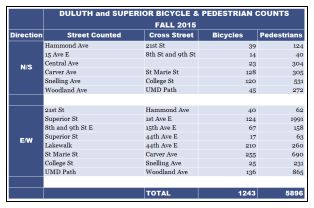
This is the fourth year of the biannual bicycle and pedestrian counts. James Gittemeier, senior planner at the MIC, and Shawna Mullen-Eardley of the Healthy Duluth Area Coalition determine count data sites, recruit and coordinate volunteers, and lead volunteer training. After attending training, each volunteer* is asked to sit for two hours at a count site and fill out a form noting direction of travel, users by demographic (male, female, child, using assistive device), and mode of transportation (walking, biking, “other”). (The method for the count was created by the National Bicycle and Pedestrian Documentation Project).
Are you getting a better idea of what goes into this seemingly simple chart?
After the day is over and all of the forms are gathered, the amazingly talented and intelligent intern (hey that’s me!) gets to decipher the notes of dozens of volunteers. The data gets entered into Excel by 15 minute increments for each demographic and each mode of transportation. Lucky for me, there is already an Excel spreadsheet that is set up to create the totals. I then finagle Excel to make those totals magically appear into this chart.
Don’t think this chart is the final product, either! After the data is entered and the totals are gathered, we begin an analysis of how the trends in the data will have an effect on future decision making for alternative transportation infrastructure. Excel is very useful in the analysis portion. So far I’ve created around 50 charts to get a better idea of visible trends.
Although I will concede that the data is not perfect – human error in counting and entering the data – the numbers tell an interesting story: The people of Duluth and Superior are outside and active.
*A huge thank you to all volunteers whether you did more than asked or did just as much as you could
…and buses (oh my!)
I can’t talk about all the time I’ve spent in Excel the last two weeks without also bringing buses into the mix.
Robert Herling, my supervisor and another senior planner at the MIC, has been researching the infrastructure use in the Lincoln Park for the Multi-modal Study that’s underway for that neighborhood.
One important aspect of this research is looking into the use of public transit.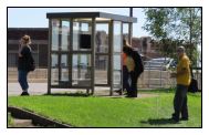
Have you ever had to transfer between two city buses to find that either the last one left just minutes prior to your arrival, or you have less than five minutes to get to the bus stop on the other side of an intersection? You should try it some time.
Robert tasked me with finding out how often this occurs for a few of the major transfers in the Lincoln Park area, from the mainline at 21st Ave W and Superior Street to the mall lines, as well as the mainline at Superior Street and Garfield to the Superior, Wisconsin line. A misstep in scheduling is not a rare occurrence for these bus users, but don’t fret! Our loyal transit authorities are not overlooking this issue.
Thanks for taking the time to join me on my journey to find out what the MIC is all about. Now I must get back to my spreadsheets.
The INTERNal Outsider
An Intern’s-Eye View of the MIC
Meet Erica Hansen
In my time as a student in the Transportation and Logistics Management program at UW-Superior, I have become increasingly enamored with the dynamics of transportation.
You might even describe me as a freight transportation enthusiast (rubber tyre gantry cranes get me fired up, okay?). The more I learn about this behind-the-scenes industry, the more apparent its presence becomes.
A few months ago when I began my journey to becoming a MIC intern, I found that there is even a behind-the-scenes transportation planning world to my behind-the-scenes freight transportation world.
I have learned that at the MIC office, “comfort level” speaks not to the ergonomics of my work space (still getting used to the stand-up desk), but to how people feel walking and biking down a road. They give you a booklet on the first day of the acronyms you’ll hear on a daily basis: “TAC” isn’t something you put into a wall to hold a paper up, it’s a group of intelligent, invested engineers and planners who look at what the Duluth-Superior area needs from a technical perspective. “TIP” isn’t the “pointed or rounded end or extremity of something slender or tapering” (thanks, dictionary.com), but the four-year Transportation Improvement Program, a tool and a process by which federal funds are made available to finance local infrastructure projects.
Here at the MIC, “intern” isn’t the person who makes the coffee and copies. In my first two weeks at the MIC, I spent several hours outside counting parked bikes, taking pictures of infrastructure use, and collecting data on bicyclists and pedestrians. I’ve attended meetings with stakeholders of the Twin Ports, and have come to an understanding of how many different views affect the decisions made here. I’ve been included in many discussions of the efforts towards making Duluth-Superior a community that supports each other, from environmentalists supporting the economy, or motorists supporting bike lanes.
Although I am an outsider to the world of urban planning, in just a short while I have become more invested in the community I’ve been a part of for over 25 years, and more understanding of the efforts to integrate the needs of all transportation users — from the pedestrian on the sidewalk to the overweight/oversized semi-trucks on the roads.
In my remaining months at the MIC, I look forward to enhancing this understanding by assisting the amiable and welcoming staff of the MIC on their various projects, whether it’s field work, office work, or lending my outsider’s view to their planning mindset.
 Erica Hansen is finishing up her final semester at the University of Wisconsin – Superior in the Transportation and Logistics Management program. She is intrigued by looking at transportation from a different side than freight movement, and helping to create an efficient and safe transportation network for the Duluth-Superior area. Erica also interns at Lake Superior Warehousing, Co. Inc. and runs student organizations at UWS. When she is not busy with these things, she takes her two-year-old to parks near their home, and rollerblades on the Munger Trail.
<br></br>
What will our Transportation System Look Like in 2040?
Updating the 25-year Vision for Transportation in the Twin Ports
You are invited to attend one of the four public meetings on Connections 2040 – the Twin Ports Long Range Transportation Plan.
The Duluth-Superior Metropolitan Interstate Council (MIC) is updating its Long Range Transportation Plan (LRTP) to provide policy guidance, goals and strategies for jurisdictions within the greater metropolitan area of Duluth, Minnesota and Superior, Wisconsin. It covers a twenty-five year planning horizon and is updated every four years.
The over-arching purpose of the LRTP is to provide a planning foundation for jurisdictions to work cooperatively to provide a well-maintained, integrated, accessible and multi-modal transportation system to safely and efficiently move people and freight for the next 25 years, within the constraints of funding the region can reasonably expect to receive.
The heart of the Plan is a listing of proposed federally-funded transportation projects, as well as transportation initiatives underway within the region, to be implemented from 2015-2040. You can view an interactive map of the projects here.
To learn more about demographic trends for this area, projections, transportation priorities and planned projects, you have three opportunities for input:
1. Attend a Public Meeting
Thurs. Sept 11, 2014
5:00-7:00pm
Community Action Duluth, 2424 W 5th Street, Duluth, MN 55806
Thurs. Sept 18, 2014
4:00-6:00pm
Superior Public Library, 1530 Tower Avenue, Superior, WI 54880
Thurs. Sept 25, 2014
4:00-6:00pm
Arrowhead Regional Development Commission (ARDC)
221 W First Street, Duluth, MN 55802
Mon. Sept 29, 2014
4:00-7:00pm (drop-in)
214 West Superior Street
221 W First Street, Duluth, MN 55802
2. Visit our Connections 2040 web page at www.dsmic.org/lrtp for more information about the plan and to view the interactive map of proposed projects. You can use the “layers” tab in the upper right corner to toggle on and off views of information about environmentally sensitive areas, low-income and minority populations, etc.
3. Contact MIC Senior Planner James Gittemeier by phone at (218) 529-7556 or by email at jgittemeier@ardc.org.
New Federally Funded Projects for 2018
An average of $86 million in federal transportation dollars is spent on transportation projects throughout the northeast region of Minnesota. 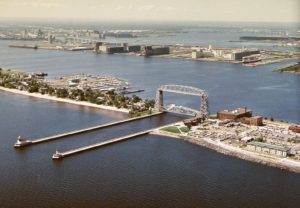
How that money is allocated
These funds are allocated according to a federal formula and managed by the state. Most of this money (about $78 million) goes to MnDOT and is used to maintain the freeways, state highways and bridges in the region. Approximately $5 million goes towards county highways, local streets, and transit in the,the MIC area. A small allocation is also made for non-roadway projects, such as paved trails, through the Transportation Alternatives Program (TAP).
Separate processes are conducted for the Duluth metro and the rest of the Arrowhead region. The MIC administers the urban-area share of the funds and the Northeast Minnesota Area Transportation Partnership (NE MN ATP) is responsible for administering the rest.
Both the MIC and the NE MN ATP solicit, evaluate and select the specific roadway, transit and trail projects that will utilize the funds in those areas. These processes have been underway since the start of the year.
Programming those funds in the TIP
As the Metropolitan Planning Organization (MPO) for this area, we are now finalizing the roster of all transportation projects slated to receive federal funding in the MIC area for the next four years.
This list is called the “TIP” (Transportation Improvement Program) and it must include all federally-funded transportation projects in the Duluth metro for the coming four years. As projects in the current year get built, we add new ones to the outer year. This time around, the outer year is 2018.
MIC Projects
It is our job to work with local communities to determine how our (increasingly scarce share of) federal transportation dollars are spent.
In a selection process that began in January, we solicited applications from local jurisdictions. These potential projects were then published for public comment, evaluated and prioritized by the MIC’s Transportation Advisory Committee (TAC) and recommended by the MIC Policy Board, submitted for consideration to the NE MN ATP, and, in June, approved for inclusion in the draft version of the Duluth Area TIP 2015-2018.
The following Duluth-area projects are being proposed for 2018 funding by the MIC:
Decker Road Preservation
Resurfacing of Decker Road from Piedmont Avenue to Mall Drive. Repairs to storm water, curb and gutter and sidewalk systems. ADA improvements and bike lanes/shoulders.
Jurisdiction: City of Duluth
Project Cost: $1,412,500
Federal funds: $ 900,000
Local funds: $ 512,500
Highway Ramp Reconstruction
Reconstruct US Hwy 2 / I-35 southbound freeway ramps
Jurisdiction: MnDOT
Project Cost: $495,670
Federal funds: $383,720
State funds: $ 95,930
Regular Route Bus Purchase
Purchase of three regular route vehicles to maintain existing fleet to safety, comfort, and efficiency standards.
Jurisdiction: Duluth Transit Authority
Bus Purchase Cost: $ 435,000
Federal funds: $ 250,000
Local funds $ 185,000
TAP Projects
In addition, the following Transportation Alternatives Program projects within the MIC have been forwarded for inclusion in the 2017 TIP projects list by the NE MN ATP:
Construct 2 miles of sidewalk along Rice Lake Road
From Central Entrance to Arrowhead Road
Jurisdiction: St. Louis County
Project Cost: $400,000
Federal funds: $320,000
Local funds: $ 80,000
Construct paved Lakewalk connection
Construct shared use path (Lakewalk) along Water St between 20th Ave East and 23rd Ave East
Jurisdiction: City of Duluth
Project Cost: $231,809
Federal funds: $185,447
Local funds: $ 46,362
We want to know what you think!
Transportation projects are public facilities and services funded with taxpayer dollars. Do you have any opinions about the importance of these proposed projects to our area?
Since they have been chosen for funding in 2018, is there anything you have to say about these specific projects?
Read the draft document
You can learn more details about these projects, as well as those lined up for years 2015, 2016 and 2017 from the draft TIP document, which is open for public comment from now until July 31.
Talk to us in person
Contact Senior Planner Robert Herling by phone at (218) 529-7573 or by email (INSERT EMAIL LINK), or…
Attend an Open House
You are invited to stop by in person to talk with us:
Wed, July 2, 7:00am – 1:00pm
Holiday Center (2nd floor skywalk level), 207 West Superior Street in downtown Duluth
Thurs, July 10, 8:00am – 5:00pm
MIC Office, 2nd floor skywalk level of the ARDC building, 221 W. First Street, Duluth.
Leave a comment at the end of this post
As we let you know on OpenMIC every year…there are three ways to have your say.
Public comments are being taken through Thursday, July 31, 2014.
Public Involvement in Transportation Planning
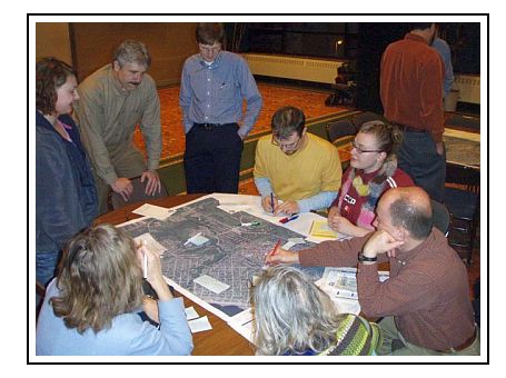
For many of us, transportation projects seem to come from nowhere. Others may vaguely remember a project “promised” years ago. Too often, people  develop negative impressions of the process by which transportation projects come into being because of the lack of information about how these decisions are made.
That’s where public involvement comes in.
Right now we are updating our Public Involvement Plan – the steps we take and the tools we use to facilitate two-way communication while our plans and studies are underway. Public involvement gives community members an opportunity to provide input and lets our planning staff provide information, answer questions and understand their perspective.
Our work at the MIC is to study, analyze and make recommendations to make it easier for people and businesses to get where they need to go—whether by car, bike, bus, on foot, by air or on water. We think about how well these transportation systems will function, and how they can be paid for, not just today but for the next 5, 10, even 25 years.
Public involvement ensures that these decisions are made with input from the people who know this area first-hand.
With this in mind, take a look at the draft of the MIC’s updated Public Involvement Plan. We understand that there’s more to public participation than holding meetings. We need to become more visible and find multiple ways to get people and organizations involved.
So let us know: will these steps help to encourage participation in the MIC’s planning activities, as well as to broaden the range of voices and views expressed?
Lincoln Park Multimodal Study (2016)-2
This plan identifies issues and makes recommendations to improve safety and connectivity for all modes of transportation in the Lincoln Park neighborhood of Duluth, Minnesota.
Complete document (75 MB)
Executive Summary (95 kb)
Document is presented here in sections (to reduce PDF size):
Part 1 (10 MB / 22 pp)
Summary / Table of Contents /
Introduction / Stakeholder Involvement
Part 2 (19 MB / 38 pp)
Land Uses / Demographics /
Growth Scenarios / Road Network
Part 3 (22 MB / 27 pp)
Freight Network / Transit System
Part 4 / (10 MB / 32 pp)
Active Transportation–Bicyclists and Pedestrians /
Multimodal Integration / Safety
Part 5 (18 MB / 29 pp)
Recommendations and Appendix
The New Normal?
As the Metropolitan Planning Organization (MPO) for this area, it’s our job to work with local jurisdictions to identify, plan for and program how federal transportation funds get used in the region. We’re already working to line up funding for construction projects that won’t begin until 2017.
Those funds, not surprisingly, have become a lot more scarce.
Last year, as part of developing the TIP, (Transportation Improvement Program), a document that allows Duluth Area communities to use federal transportation dollars, we were talking about divvying up about $7.5 million in federal highway transportation funds for local roadway projects throughout Northeast Minnesota.
This year, the funding allocation for the same area is about $5 million. Of that amount, $2.1 will go for projects to improve roads and transit services throughout Duluth, Hermantown and Proctor.
Spending to Meet Performance Goals
So, working within the “new normal” of funding restraints, it’s more important than ever to decide on projects that will fix critical maintenance needs. (Not to mention, new construction is pretty much off the table). These federal dollars do have strings attached: they need to be spent on projects that will meet performance goals, i.e., to improve safety and traffic flow, in measurable ways.
Every year, jurisdictions in the Duluth metro (the Cities of Duluth and Hermantown as well as St. Louis County) tell us which projects they’d like to use federal funds for and we work with our Technical Advisory Committee (TAC) and Policy Board to decide which ones are the most important.
We Want to Hear from You
Transportation projects are public facilities and services funded with taxpayer dollars, and therefore local citizens have a right to weigh in on such decisions, along with the planners, engineers and elected officials.
This year, the following transportation projects are being proposed by the City of Duluth, St. Louis County and the Duluth Transit Authority for our area:
- Mesaba Ave Repairs – Concrete and joint repairs from Central Entrance to I-35 and repairs to bridges over Superior Street and 2nd Ave West
- East 4th Street Repairs – Mill & overlay, safety improvements and ADA improvements (pedestrian ramps) from 6th Avenue East to Wallace Avenue
- DTA STRIDE Buses – Purchase of three STRIDE replacement buses to maintain existing fleet to safety, comfort, and efficiency standards
Do you have any opinions
…about the importance of these proposed projects to our area?
Talk to Us – Online, In Person or by Phone:
- Make a comment, below, or
- Stop by our office at 221 West First Street, ARDC entrance on the Skywalk level, or
- Call me with questions or comments–Robert Herling at (218) 529-7573.
Although it’s only March 2013, NOW is the time to give us your input on these proposed projects before funding decisions are made for 2017.
You have three ways to let us know.
Break Trail While the Sun Shines (and Plan for Them All Year Round)
This past week, after our first snowfall of the season, it’s been easy to spot the routes that people take when they travel on foot. 
Previously-invisible pedestrian pathways are revealed as the snow is packed down underfoot. Some are traversed only lightly while others are obviously heavily used. Some are tough going while others are (comparatively) easy to negotiate on foot.
The Lincoln Park Pedestrian Plan, one of our recent planning efforts, was dedicated to discovering that same information — what routes people (especially school-aged children) take as they make their way through the neighborhood and how “walkable” those pathways are.
During a walkability audit in the summer of 2011, an overgrown segment of Devonshire Street was identified as a significant barrier between the new Lincoln Park Middle School and the adjacent neighborhood. (Check out the “before” picture, below, which shows James Gittemeier, a Senior Planner with the MIC, pointing out where a new trail could be built).
Community Trail Project
Two weeks ago (aided by a fortunate fair-weather interlude), students and community members worked to bridge that gap by building a new trail connection to the school. By clearing brush, digging up roots and rocks and placing gravel, they created a footpath that links the existing sidewalks along Devonshire Street.
The result is a direct route between the school and the eastern section of the adjacent neighborhood as well as a pathway with a more gradual slope in a neighborhood perched on one of Duluth’s steepest hillsides. (In the “after” picture, at top of the page, you can see how there’s now a trail there, and that it’s being used even in the winter).
Community Planning Partners
The finished project may look like a simple little trail, but it’s a great example of how the MIC can leverage the resources and missions of mul tiple community partners to achieve mutual goals.
The MIC, as the MPO for Duluth and Superior, has a primary, long-term goal of developing a safe, integrated, multimodal transportation network for this region.
Project partners in this effort, the Healthy Duluth Area Coalition, the St. Louis County Public Health and Human Services Statewide Health Improvement Program (SHIP) have a primary, long-term goal of encouraging active lifestyles for our kids.
The City of Duluth, through its Comprehensive Plan and Parks and Trails initiatives, has a primary, long-term goal of strengthening neighborhoods by creating and maintaining connectivity through its sidewalks, bikeways and trails.
Safe Routes to School Planning
The Devonshire trail was a small, manageable project that began with conversations the MIC has had within the neighborhood and accomplished with the help of community volunteers of all ages.
We are now undertaking a new planning Safe Routes to School initiative to build on this work and this neighborhood enthusiasm.
Stay tuned for more information as we work to involve the community in what we hope will be another successful “before” and “after” planning effort.
An Intern’s-Eye View
 What is the MIC, Anyway, and What Do They Do?
Have you ever wondered how great trails such as the Lakewalk come about or what goes in to planning the major road construction projects you see around town? Well, this summer I gained some insight into this process through my internship with the Duluth-Superior Metropolitan Interstate Council, or the MIC.
With one year remaining in my Environment and Sustainability program at the University of Minnesota-Duluth, I was able to gain valuable experience in the professional world of transportation and land use planning.
What I have gained most in my time at the MIC is a greater appreciation for the intricacies of the transportation network and a motivation for creating healthier and more sustainable ways for the people of the Twin Ports to move about their city.
The folks at the MIC come to work each day with the goal of making the transportation system in the Twin Ports as friendly as possible for all of its users. They have the tough task of creating a network that balances the needs of all types of commuters, and connects our citizens in the most safe, efficient and sustainable ways possible.
The MIC also provided me with a good avenue to express my sustainable development concerns and promote alternative transportation options.
 The summer months offer prime conditions for focusing on bicycle behavior and infrastructure. I assisted the MIC in conducting the first-ever count of bicycles and pedestrians in the East Hillside neighborhood, hosting a Bikeable Community Workshop, and finding ways to accommodate bicyclists in the new DTA Multimodal Transportation Center.
As I head back to school this fall and leave the MIC in a formal sense, I look forward to continuing to work on these same issues in the academic realm. I also am excited to see these projects come to fruition, particularly the upcoming bike/ped count this September and the development of the Multimodal Transportation Center.
Perhaps what I’ll miss most is my bicycle commute to the office by way of the Lakewalk each day as my destination is up the hill to campus now. But I’ll still be out there plenty, and looking forward to the future completion of the Cross City Trail, as well as the other great projects the folks at the MIC are tackling.
Duluth-Superior’s Harbor Technical Advisory Committee: A Model for Successful Stakeholder Participation & Coordination
 “A committee that actually gets work done”
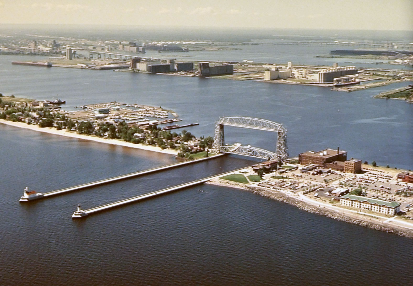
The HTAC is a working group for addressing challenges and opportunities in the Duluth-Superior harbor, while promoting the port’s economic and environmental importance to both communities.
It is one of three advisory committees to the Metropolitan Interstate Council (MIC), the federally designated Metropolitan Planning Organization (MPO) for the Duluth-Superior urbanized area.
And it is unique–the only stakeholder group of its kind in the country.
More important, it is, in the words of former Duluth Seaway Port Authority Director Adolf Ojard, “a committee that actually gets work done.”
Complexity, Controversy and Collaboration
Port-centered issues are usually complex, often controversial and sometimes downright contentious: dredged material management; marine safety; port security; land and recreational uses; economic development proposals; accelerated corrosion of maritime infrastructure; ballast water and invasive species management; legacy environmental degradation and habitat restoration initiatives –to name a few.
None of these problems affects one group alone, and none can be addressed except through the coordinated action of many diverse organizations and individuals. The HTAC has emerged as a national model for doing just that, through planning, collaboration, information sharing and long-term institutional involvement.
Its diverse members all hold a stake in the continued success and health of the harbor. Participation on the HTAC encourages representatives from industry, government, academic, environmental, regulatory and citizen groups on both sides of the bridge to recognize that although they have distinct missions they also have shared goals.
HTAC members, in other words, are genuine stakeholders who have, over its 20-year history, learned the value of playing nice and working hard together.
Result: a new paradigm for dredge material handling
 One recent example of the HTAC’s successful, collaborative planning process is what’s happening at Erie Pier. It might seem a little hard to get excited about this “hidden in plain sight” facility on the Duluth waterfront—but it represents an entirely new paradigm for dredge material handling.
Thanks to the efforts of many HTAC members who undertook an intensive multi-year planning process, and to the US Army Corps of Engineers which subsequently agreed to make a significant investment in redesigning and re-engineering the facility, a major physical restructuring of the full-to-capacity Contained Disposal Facility at Erie Pier was undertaken to convert it to a Recycle-Reuse Facility. It utilizes hydraulic sorting to separate out the clean, uncontaminated sand and silt that’s dredged from the shipping channels for reuse in large-scale projects such as road construction and landfill cover.
The Duluth Seaway Port Authority now manages Erie Pier dredge materials as a valuable, re-usable resource instead of a waste product. By creating a cost effective and environmentally sound alternative to standard dredge material disposal practices, it will save local taxpayers the millions of dollars it would have cost to develop a new CDF.
Sincerest form of flattery
It also has the potential to change the way other Great Lakes ports manage their dredging operations. Erie Pier has recently gained the attention of the Canadian federal government, which is looking at the Erie Pier facility as a model for a new hydraulic sorting procedure at one or more of their dredging sites.
Most port communities face similar challenges. For this reason, we’ve been invited to present the HTAC model at many national-level planning and port conferences in recent years.
More Information/Get Involved
You can follow or participate in this notable initiative that’s happening right here in Duluth-Superior. For more information or to get on our meeting mailing list, check out the HTAC page on the MIC website at dsmic.org/htac.
Writing credit: Andy McDonald contributed to this article.
Photo credits:
Duluth-Superior Harbor aerial view – Gary Lidholm, USDA Forest Service, Superior National Forest
Erie Pier aerial view – Google Earth 2010

