Lincoln Park Multimodal Study (2016)-2

This plan identifies issues and makes recommendations to improve safety and connectivity for all modes of transportation in the Lincoln Park neighborhood of Duluth, Minnesota.

Click to view plan

Complete document (75 MB)


Click to view document

Executive Summary (95 kb)


Document is presented here in sections (to reduce PDF size):

Click to view doument

Part 1 (10 MB / 22 pp)
Summary / Table of Contents /
Introduction / Stakeholder Involvement


Click to view document

Part 2 (19 MB / 38 pp)
Land Uses / Demographics /
Growth Scenarios / Road Network


Click to view document

Part 3 (22 MB / 27 pp)
Freight Network / Transit System


Click to view document

Part 4 / (10 MB / 32 pp)
Active Transportation–Bicyclists and Pedestrians /
Multimodal Integration / Safety


Click to view document

Part 5 (18 MB / 29 pp)
Recommendations and Appendix

The New Normal?

As the Metropolitan Planning Organization (MPO) for this area, it’s our job to work with local jurisdictions to identify, plan for and program how federal transportation funds get used in the region.  We’re already working to line up funding for construction projects that won’t begin until 2017.

Those funds, not surprisingly, have become a lot more scarce.

Last year, as part of developing the TIP, (Transportation Improvement Program), a document that allows Duluth Area communities to use federal transportation dollars, we were talking about divvying up about $7.5 million in federal highway transportation funds for local roadway projects throughout Northeast Minnesota.

This year, the funding allocation for the same area is about $5 million.  Of that amount, $2.1 will go for projects to improve roads and transit services throughout Duluth, Hermantown and Proctor.

Spending to Meet Performance Goals

So, working within the “new normal” of funding restraints, it’s more important than ever to decide on projects that will fix critical maintenance needs.  (Not to mention, new construction is pretty much off the table). These federal dollars do have strings attached: they need to be spent on projects that will meet performance goals, i.e., to improve safety and traffic flow, in measurable ways.

Every year, jurisdictions in the Duluth metro (the Cities of Duluth and Hermantown as well as St. Louis County) tell us which projects they’d like to use federal funds for and we work with our Technical Advisory Committee (TAC) and Policy Board to decide which ones are the most important.

We Want to Hear from You

Transportation projects are public facilities and services funded with taxpayer dollars, and therefore local citizens have a right to weigh in on such decisions, along with the planners, engineers and elected officials.

This year, the following transportation projects are being proposed by the City of Duluth, St. Louis County and the Duluth Transit Authority for our area:

  • Mesaba Ave Repairs – Concrete and joint repairs from Central Entrance to I-35 and repairs to bridges over Superior Street and 2nd Ave West
  • East 4th Street Repairs – Mill & overlay, safety improvements and ADA improvements (pedestrian ramps) from 6th Avenue East to Wallace Avenue
  • DTA STRIDE Buses – Purchase of three STRIDE replacement buses to maintain existing fleet to safety, comfort, and efficiency standards

Do you have any opinions

…about the importance of these proposed projects to our area?

Talk to Us – Online, In Person or by Phone:

  1. Make a comment, below,  or
  2. Stop by our office at 221 West First Street, ARDC entrance on the Skywalk level, or
  3. Call me with questions or comments–Robert Herling at (218) 529-7573.

Although it’s only March 2013, NOW is the time to give us your input on these proposed projects before funding decisions are made for 2017.

You have three ways to let us know.

Break Trail While the Sun Shines (and Plan for Them All Year Round)

This past week, after our first snowfall of the season, it’s been easy to spot the routes that people take when they travel on foot. 

Previously-invisible pedestrian pathways are revealed as the snow is packed down underfoot.  Some are traversed only lightly while others are obviously heavily used.  Some are tough going while others are (comparatively) easy to negotiate on foot.

The Lincoln Park Pedestrian Plan, one of our recent planning efforts, was dedicated to discovering that same information — what routes people (especially school-aged children) take as they make their way through the neighborhood and how “walkable” those pathways are.

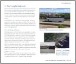
During a walkability audit in the summer of 2011, an overgrown segment of Devonshire Street was identified as a significant barrier between the new Lincoln Park Middle School and the adjacent neighborhood.  (Check out the “before” picture, below, which shows James Gittemeier, a Senior Planner with the MIC, pointing out where a new trail could be built).

Community Trail Project

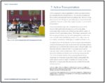
Two weeks ago (aided by a fortunate fair-weather interlude), students and community members worked to bridge that gap by building a new trail connection to the school.  By clearing brush, digging up roots and rocks and placing gravel, they created a footpath that links the existing sidewalks along Devonshire Street.

The result is a direct route between the school and the eastern section of the adjacent neighborhood as well as a pathway with a more gradual slope in a neighborhood perched on one of Duluth’s steepest hillsides. (In the “after” picture, at top of the page, you can see how there’s now a trail there, and that it’s being used even in the winter).

Community Planning Partners

The finished project may look like a simple little trail, but it’s a great example of how the MIC can leverage the resources and missions of multiple community partners to achieve mutual goals.

The MIC, as the MPO for Duluth and Superior, has a primary, long-term goal of developing a safe, integrated, multimodal transportation network for this region.

Project partners in this effort, the Healthy Duluth Area Coalition, the St. Louis County Public Health and Human Services Statewide Health Improvement Program (SHIP) have a primary, long-term goal of encouraging active lifestyles for our kids.

The City of Duluth, through its Comprehensive Plan and Parks and Trails initiatives, has a primary, long-term goal of strengthening neighborhoods by creating and maintaining connectivity through its sidewalks, bikeways and trails.

Safe Routes to School Planning

The Devonshire trail was a small, manageable project that began with conversations the MIC has had within the neighborhood and accomplished with the help of community volunteers of all ages.

We are now undertaking a new planning Safe Routes to School initiative to build on this work and this neighborhood enthusiasm.

Stay tuned for more information  as we work to involve the community in what we hope will be another successful “before” and “after” planning effort.


An Intern’s-Eye View

What is the MIC, Anyway, and What Do They Do?

Have you ever wondered how great trails such as the Lakewalk come about or what goes in to planning the major road construction projects you see around town?  Well, this summer I gained some insight into this process through my internship with the Duluth-Superior Metropolitan Interstate Council, or the MIC.

With one year remaining in my Environment and Sustainability program at the University of Minnesota-Duluth, I was able to gain valuable experience in the professional world of transportation and land use planning.

What I have gained most in my time at the MIC is a greater appreciation for the intricacies of the transportation network and a motivation for creating healthier and more sustainable ways for the people of the Twin Ports to move about their city.

The folks at the MIC come to work each day with the goal of making the transportation system in the Twin Ports as friendly as possible for all of its users.  They have the tough task of creating a network that balances the needs of all types of commuters, and connects our citizens in the most safe, efficient and sustainable ways possible.

The MIC also provided me with a good avenue to express my sustainable development concerns and promote alternative transportation options.

The summer months offer prime conditions for focusing on bicycle behavior and infrastructure. I assisted the MIC in conducting the first-ever count of bicycles and pedestrians in the East Hillside neighborhood, hosting a Bikeable Community Workshop, and finding ways to accommodate bicyclists in the new DTA Multimodal Transportation Center.

As I head back to school this fall and leave the MIC in a formal sense, I look forward to continuing to work on these same issues in the academic realm.  I also am excited to see these projects come to fruition, particularly the upcoming bike/ped count this September and the development of the Multimodal Transportation Center.

Perhaps what I’ll miss most is my bicycle commute to the office by way of the Lakewalk each day as my destination is up the hill to campus now.  But I’ll still be out there plenty, and looking forward to the future completion of the Cross City Trail, as well as the other great projects the folks at the MIC are tackling.


The Best Laid Plans

Last Tuesday night we presented information and took questions at a public meeting about our Central Entrance Transportation Plan.  It was raining hard when the meeting wrapped up around 7 pm.

And it kept raining hard all night long.

By Wednesday morning, the City of Duluth had declared a state of emergency, due to the torrential downpour that caused widespread flooding and heavy damage to infrastructure.  The cities of Superior, Hermantown and Proctor, all within the MIC’s planning area, followed suit shortly thereafter.

We received some good comments and questions at the Central Entrance meeting, which we had planned to address in this week’s blog.

But the transportation issues and priorities for this community have dramatically changed – literally overnight.

All of the area’s jurisdictions are currently in assessment mode and the extent of the damage is still being tallied.  While the concerns expressed at the meeting, about traffic calming, walkability and access management, are all still valid—right now public safety and damage control initiatives take precedence.

The MIC has conducted numerous planning efforts up to this point, which may or may not be relevant to the damaged infrastructure.

We will be revisiting the recommendations from many of our past plans and studies to prepare for the coordinated work of rebuilding our transportation system for the enhancement of our communities.


Photos: Robert Herling and James Gittemeier

Editorial assistance: Robert Herling