Why do YOU bike to work?

We interviewed a few folks in and around our office about their reasons for biking to work.  Their message: biking is a healthy, economical and fun transportation alternative.

httpv://www.youtube.com/watch?v=xxiNQu5qK_0

We hope you’ll be inspired or encouraged to join us for Bike to Work Day on
Friday, May 18.

You’re invited to stop by one of our bike commuter stations from 6:30 am
to 8:30 am and reward your commute with:

  • Free coffee and refreshments
  • Bike mechanics to look at brakes, tire pressure and other safety checks
  • Copies of the Duluth-Superior Bike Map

The bike stations will be located at:

  • Duluth: Lake Ave &Superior Street (Minnesota Power Plaza)
  • Superior: Tower Ave & Belknap Street (City Center Park)
  • Stop by and tell us why YOU biked to work!

    Click to see our Bike to Work event page on Facebook

    Video footage and editing by Robert Herling, Jodi Jabas and James Gittemeier

    Duluth-Superior’s Harbor Technical Advisory Committee: A Model for Successful Stakeholder Participation & Coordination

    Aerial view of the Ports of Duluth-Superior “A committee that actually gets work done”

    The HTAC is a working group for addressing challenges and opportunities in the Duluth-Superior harbor, while promoting the port’s economic and environmental importance to both communities.

    It is one of three advisory committees to the Metropolitan Interstate Council (MIC), the federally designated Metropolitan Planning Organization (MPO) for the Duluth-Superior urbanized area.

    And it is unique–the only stakeholder group of its kind in the country.

    More important, it is, in the words of former Duluth Seaway Port Authority Director Adolf Ojard, “a committee that actually gets work done.”

    Complexity, Controversy and Collaboration

    Port-centered issues are usually complex, often controversial and sometimes downright contentious: dredged material management; marine safety; port security; land and recreational uses; economic development proposals; accelerated corrosion of maritime infrastructure; ballast water and invasive species management; legacy environmental degradation and habitat restoration initiatives –to name a few.

    None of these problems affects one group alone, and none can be addressed except through the coordinated action of many diverse organizations and individuals. The HTAC has emerged as a national model for doing just that, through planning, collaboration, information sharing and long-term institutional involvement.

    Its diverse members all hold a stake in the continued success and health of the harbor. Participation on the HTAC encourages representatives from industry, government, academic, environmental, regulatory and citizen groups on both sides of the bridge to recognize that although they have distinct missions they also have shared goals.

    HTAC members, in other words, are genuine stakeholders who have, over its 20-year history, learned the value of playing nice and working hard together.

    Result: a new paradigm for dredge material handling

    Aerial view of Erie Pier re-engineered as a PRFOne recent example of the HTAC’s successful, collaborative planning process is what’s happening at Erie Pier. It might seem a little hard to get excited about this “hidden in plain sight” facility on the Duluth waterfront—but it represents an entirely new paradigm for dredge material handling.

    Thanks to the efforts of many HTAC members who undertook an intensive multi-year planning process, and to the US Army Corps of Engineers which subsequently agreed to make a significant investment in redesigning and re-engineering the facility, a major physical restructuring of the full-to-capacity Contained Disposal Facility at Erie Pier was undertaken to convert it to a Recycle-Reuse Facility.  It utilizes hydraulic sorting to separate out the clean, uncontaminated sand and silt that’s dredged from the shipping channels for reuse in large-scale projects such as road construction and landfill cover.

    The Duluth Seaway Port Authority now manages Erie Pier dredge materials as a valuable, re-usable resource instead of a waste product.  By creating a cost effective and environmentally sound alternative to standard dredge material disposal practices, it will save local taxpayers the millions of dollars it would have cost to develop a new CDF.

    Sincerest form of flattery

    It also has the potential to change the way other Great Lakes ports manage their dredging operations.  Erie Pier has recently gained the attention of the Canadian federal government, which is looking at the Erie Pier facility as a model for a new hydraulic sorting procedure at one or more of their dredging sites.

    Most port communities face similar challenges.  For this reason, we’ve been invited to present the HTAC model at many national-level planning and port conferences in recent years.

    More Information/Get Involved

    You can follow or participate in this notable initiative that’s happening right here in Duluth-Superior.  For more information or to get on our meeting mailing list, check out the HTAC page on the MIC website at dsmic.org/htac.

    Writing credit: Andy McDonald contributed to this article.

    Photo credits:
    Duluth-Superior Harbor aerial view – Gary Lidholm, USDA Forest Service, Superior National Forest

    Erie Pier aerial view – Google Earth 2010

    What Have We Done for You Lately?

    We at the MIC are transportation planners. We lay the groundwork for projects that use federal tax dollars.

    Large, public, tax-funded infrastructure requires a huge investment of federal, state and local funds—but then, our region’s mobility, quality of life, economic growth and competitiveness rely on the transportation network. Every household and business depends on safe, multi-modal transportation infrastructure for moving people and goods.

    Local input,  coordination, and planning expertise

    Our job is to coordinate with all local jurisdictions so the money for this infrastructure is well-spent and reflects local priorities.

    We at the MIC are also elected officials. Our Board members represent all local units of government in the Duluth-Superior area—states, counties, cities and townships. Because these neighboring jurisdictions all have responsibilities and make decisions that impact the transportation system, coordination is key to making efficient use of limited financial resources.

    And the term “stakeholder” is the real deal for us – figuring out and working with those who have a vested interest in the decisions that get made. Our job is to work with the right people – planners, engineers, local officials – to set joint priorities for funding projects, agree on timelines, and to share information about the projects we’re up to.

    Bottom-up planning process

    This kind of cooperative process is what Metropolitan Planning Organizations (MPOs) like the MIC are designed to do, here and across the country. We facilitate a bottom-up approach to transportation planning, allowing for local input into decisions how federal funds are spent, instead of a top-down approach that would make decisions about local projects and priorities at the federal or state level.

    Planning Successes

    Most important, this planning process is getting real results in our area. Here are some of our planning successes:

    HTAC: a national model

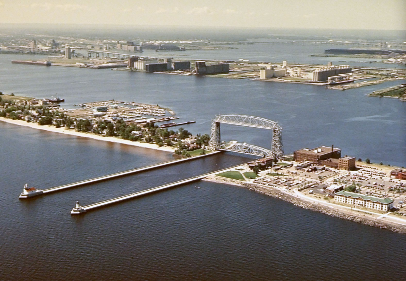
    Our Harbor Technical Advisory Committee, or HTAC, is recognized as a national model for doing just that—getting the right people in the room to solve problems. The HTAC is a nationally-recognized, bi-state forum to discuss issues confronting the Ports of Duluth and Superior. The HTAC brings together a broad range of industry, environmental and government stakeholders to provide sound planning and management recommendations and to promote the harbor’s economic and environmental importance to our community.

    Erie Pier Management Plan: first of its kind on the Great Lakes

    HTAC stakeholders have worked for many years to craft the Erie Pier Management Plan, a blueprint for transitioning the Erie Pier Confined Disposal Facility (CDF) to a first-of-its kind Processing and Reuse Facility (PRF). By creating a cost effective and environmentally sound alternative to current dredge material disposal practices for Great Lakes ports, this innovative Plan will save local taxpayers the millions of dollars it would have cost to develop a new CDF.

    Landside Port Access Study: targeted roadway construction

    The Landside Port Access Study was used to educate the public and policy makers about the land-based access needs of the Port and laid the foundation for funding a new roadway project (Helberg Drive) to improve access and safety.

    Corridor planning: addressing problems before they arise

    The MIC’s Corridor Planning initiatives seek to be proactive, by identifying and addressing problems along local roadways before they arise. They balance mobility needs with adjoining land uses and environmental and community interests.

    Our North 28th Street Plan identified and made recommendations to alleviate critical transportation issues on North 28th Street, in Superior, in advance of planned road reconstruction. Significant safety concerns needed to be addressed due to several conflicting land uses, including the construction of three new schools, a skate park, a recreational trail, housing units and a newly-developed commercial area.

    The Duluth Heights Traffic Circulation Study was undertaken at the request of neighbors and local elected officials to address the issue of residential streets being used as an unwelcome and unintended thoroughfare to a commercial district. Using an extensive public participation process, MIC staff worked closely with residents to document the level of cut-through traffic, and identify options to reduce impacts and improve flow in and around the neighborhood.

    This planning process set the groundwork for the City to pursue funding for a new roadway connection (Joshua Avenue) between the Miller Hill commercial district and the east side of Duluth.

    Long Range Planning: coordinated goals and strategies

    The MIC’s Long Range Planning initiatives provide policy guidance, goals and coordinated strategies for jurisdictions within the greater metropolitan area of Duluth, MN and Superior, WI.

    Directions 2035 is our Long Range Transportation Plan, setting forth a vision for the area-wide transportation network for the next 25 years. The LRTP provides a framework for working cooperatively to provide a well-maintained, integrated, accessible and multi-modal transportation system to safely and efficiently move people and freight, within the constraints of funding the region can reasonably expect to receive.

    The Duluth Urban Area Growth Impact Study examines how best to accommodate growth in areas outside the urban services boundary while ensuring taxpayer protection from the consequences of inefficient patterns of development. Future land use information from each jurisdiction was used as part of a regional planning process to examine growth impacts and to identify the specific areas best suited for development.

    Bike, Pedestrian and Transit Planning: mobility and quality of life

    The MIC’s planning initiatives for modes of travel that are not centered on cars and trucks account annually for about 20% of our work program and budget. They are important because they aim to improve access, mobility and quality of life for all people in our area, regardless of age or physical ability, whether they travel by car, bike, bus or on foot.

    The MIC’s Bicycle and Pedestrian Advisory Committee (BPAC) engages local stakeholders to provide sound planning recommendations and to provide public outreach and education about bike- and pedestrian-related plans and projects.

    The Duluth-Superior Area Bike Map is our most popular product, an award-winning guide to the best on- and off-street bike routes in and through this region.

    The Duluth Sidewalk Study provides technical and policy guidance to assist local elected officials in working with neighborhoods during roadway reconstruction projects. The GIS-based interactive map is a powerful tool for decision makers to apply data to the sometimes-contentious discussions about locating sidewalks on local streets.

    Safe Routes to School (SRTS) Plans: The MIC was an early proponent of SRTS planning, working closely with many community stakeholders collecting data, conducting field observations and identifying safety issues around schools. The MIC’s recommendations have been incorporated into many funded projects to improve bike and pedestrian access to schools in the cities of Duluth, Superior and Proctor.

    Transit Planning: The MIC provides ongoing input and technical assistance on local transit initiatives including planning and securing funding for a future downtown multimodal facility. Results from a recent ridership survey will be utilized by MnDOT to determine the potential for utilizing transit service to mitigate the effects of major construction projects statewide.

    This is where you come in

    Hopefully this gives you an idea of how we have worked (for nearly forty years!) to ensure that federally-funded infrastructure investments are developed with input from the people who know this area best.  As a local resident, do our planning initiatives reflect your priorities?

    What Makes an Award-Winning Bike Map?

    Congratulations to our GIS Specialist Kody Thurnau. His redesign of our popular Duluth-Superior Metropolitan Bike Map took not one but two awards from juries of his peers at the 2011 Esri International User Conference in San Diego, CA.

    The map was awarded first prize in the category Best Cartographic Design Single Map Product – Large Format Press Copy.  Judged by 38 Esri staff members for general and specific cartographic quality, entries in this category had to be a single map product larger than 11 in. x 17 in. but not exceeding 48 in., printed professionally on a printing press.

    The map was also one of three overall winners of the Cartography Special Interest Group (Carto SIG) Map Awards, out of 1,200 conference Map Gallery entries.

    Judging criteria included ‛efficiency in communication of intended message’ and ‛maximization of the user’s cognitive experience.’  More specifically, the judges appreciated:

    • Its compact size
    • Its design, layout and the way it’s strategically folded
    • Its scale and legibility
    • Its topographical info
    • Its easily identified green space destinations
    • Its urban area destinations, including local bike shops
    • Its information about different riding surfaces
    • Its information about designated bike routes

    In other words, it’s perfectly designed to for people who want to bike in, around or between Duluth and Superior, whether you’re a recreational rider or an urban commuter.

    Your guide to biking Duluth and Superior

    You can pick up own copy of the Duluth-Superior Metropolitan Bike Map at local bike shops, tourist information outlets or email us at dsmic01@gmail.com and we’ll mail you a copy.

    Next up: online interactive version

    Right now we have a pdf version of the map available for you to download on our website.  Never fear, Kody is hard at work converting the print version into an interactive map you’ll be able to access and use online.

    Moving Stuff by Water – Cheaper, Safer, Greener

    We were reminded at today’s National Maritime Day celebration at the DECC that maritime transportation is vital part of the national and our own local economy.

    Waterborne transport efficiently moves both bulky natural resource materials and finished goods to global destinations.

    Jim Weakly, president of the Lake Carriers’Association, in his keynote address, pointed out that Without water transportation the cost of all goods would be much higher.  Moving bulk goods by water is the most efficient, least costly, safest and most environmentally friendly method of transportation.  If water transportation was not available, all of those goods and materials would have to move by land which would increase congestion and cause higher levels of air pollution due to increased fuel use.

    The Forgotten Mode?

    Maritime transportation can be the forgotten method of moving goods and people—even here in Duluth, home of many a boat nerd.  Ships are visible to the general public when they are in port but while in transit may be many miles from shore and it’s out of sight, out of mind.

    Here in the Twin Ports, iron ore from the Minnesota Iron Range moves to steel mills in the lower Great Lakes. Grain from western Minnesota and the eastern Dakotas moves to destinations throughout the world.  Nationally and internationally, finished consumer export and import goods arrive and depart from our coastal ports.  Almost everything we consume has at some point moved by water.

    National Maritime Day

    Originally held in observance of the value and importance of the U.S. maritime industry, National Maritime Day commemorated May 22, 1819, when the SS SAVANNAH sailed from her home port of Savannah, Ga., bound for Liverpool, England, becoming the first steam vessel to cross the Atlantic Ocean.  The observance later became more of a day to honor merchant mariners and merchant marine veterans, primarily those involved in WWII and other armed conflicts around the world.

    Today, through efforts of numerous organizations including the Propeller Club of the United States, National Maritime Day is observed as a combined salute to merchant mariners, merchant marine veterans and the entire maritime industry, focusing attention on the benefits maritime brings to America’s economy, trade, national security, employment, environmental protection, recreation and quality of life.

    M/V Hon. James L. Oberstar

    The Interlake Steamship Company has announced the renaming of the ship Charles M. Beeghly in recognition of the Hon. James Oberstar, retired United States Congressman from the State of Minnesota.  The naming of the ship is in recognition of Congressman Oberstar’s work toward improving maritime transportation in the Great Lakes.  A ceremony christening the newly named ship will be held harbor side of the DECC on Tuesday May 23 at 10:30am.