Lincoln Park Multimodal Study (2016)-2

This plan identifies issues and makes recommendations to improve safety and connectivity for all modes of transportation in the Lincoln Park neighborhood of Duluth, Minnesota.

Click to view plan

Complete document (75 MB)


Click to view document

Executive Summary (95 kb)


Document is presented here in sections (to reduce PDF size):

Click to view doument

Part 1 (10 MB / 22 pp)
Summary / Table of Contents /
Introduction / Stakeholder Involvement


Click to view document

Part 2 (19 MB / 38 pp)
Land Uses / Demographics /
Growth Scenarios / Road Network


Click to view document

Part 3 (22 MB / 27 pp)
Freight Network / Transit System


Click to view document

Part 4 / (10 MB / 32 pp)
Active Transportation–Bicyclists and Pedestrians /
Multimodal Integration / Safety


Click to view document

Part 5 (18 MB / 29 pp)
Recommendations and Appendix

The New Normal?

As the Metropolitan Planning Organization (MPO) for this area, it’s our job to work with local jurisdictions to identify, plan for and program how federal transportation funds get used in the region.  We’re already working to line up funding for construction projects that won’t begin until 2017.

Those funds, not surprisingly, have become a lot more scarce.

Last year, as part of developing the TIP, (Transportation Improvement Program), a document that allows Duluth Area communities to use federal transportation dollars, we were talking about divvying up about $7.5 million in federal highway transportation funds for local roadway projects throughout Northeast Minnesota.

This year, the funding allocation for the same area is about $5 million.  Of that amount, $2.1 will go for projects to improve roads and transit services throughout Duluth, Hermantown and Proctor.

Spending to Meet Performance Goals

So, working within the “new normal” of funding restraints, it’s more important than ever to decide on projects that will fix critical maintenance needs.  (Not to mention, new construction is pretty much off the table). These federal dollars do have strings attached: they need to be spent on projects that will meet performance goals, i.e., to improve safety and traffic flow, in measurable ways.

Every year, jurisdictions in the Duluth metro (the Cities of Duluth and Hermantown as well as St. Louis County) tell us which projects they’d like to use federal funds for and we work with our Technical Advisory Committee (TAC) and Policy Board to decide which ones are the most important.

We Want to Hear from You

Transportation projects are public facilities and services funded with taxpayer dollars, and therefore local citizens have a right to weigh in on such decisions, along with the planners, engineers and elected officials.

This year, the following transportation projects are being proposed by the City of Duluth, St. Louis County and the Duluth Transit Authority for our area:

  • Mesaba Ave Repairs – Concrete and joint repairs from Central Entrance to I-35 and repairs to bridges over Superior Street and 2nd Ave West
  • East 4th Street Repairs – Mill & overlay, safety improvements and ADA improvements (pedestrian ramps) from 6th Avenue East to Wallace Avenue
  • DTA STRIDE Buses – Purchase of three STRIDE replacement buses to maintain existing fleet to safety, comfort, and efficiency standards

Do you have any opinions

…about the importance of these proposed projects to our area?

Talk to Us – Online, In Person or by Phone:

  1. Make a comment, below,  or
  2. Stop by our office at 221 West First Street, ARDC entrance on the Skywalk level, or
  3. Call me with questions or comments–Robert Herling at (218) 529-7573.

Although it’s only March 2013, NOW is the time to give us your input on these proposed projects before funding decisions are made for 2017.

You have three ways to let us know.

Central Entrance Survey Results Are In:

Let’s Make Life a Whole Lot Easier for This Guy


Person attempting to cross busy Central Entrance roadway in the center turn lane, Duluth MN
The City of Duluth has an interesting long-term vision for Central Entrance.  They, along with area residents and businesses, see it as having the potential to be an inviting and attractive destination within the City.  They would like it to function as the “main street” of the Duluth Heights neighborhood and become more walkable with better access to area businesses.

Which is almost hard to imagine, if you agree with the many other residents who currently regard Central Entrance as basically unpleasant—as a road to be tolerated while running errands or going to work, if not outright avoided.

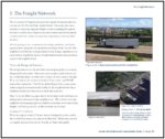
And there’s a reason for this.  Central Entrance is classified as a principal arterial roadway, meant to efficiently move high volumes of traffic between urban areas.  Although a vital cog in Duluth’s transportation system, Central Entrance is simply not conducive to modes of travel besides driving—to people walking or biking, as you would expect along a true “main street.”

The Transportation Experience

Our Central Entrance Corridor Study, currently underway, aims to identify ways to improve the transportation experience for everyone, drivers and non-drivers alike, who travels along that roadway.

Specifically, we are examining the transportation network in this area and identifying changes that will make the corridor more compatible with the vision for the future land use.  The ultimate objective is to maintain traffic mobility and flow, while improving safety and that sense of livability that a “town center” or “main street” implies.

As part of our planning process, some of the data we’ve collected so far includes information about the roadway such as sidewalk locations, bike routes, transit routes and stops, driveway access points, traffic counts, traffic control locations and types, and crash information.

Traveler Survey – Baseline Attitudes

We also conducted a survey to assess people’s attitudes toward traveling on Central Entrance.  Postcards were mailed to 3000 residents and businesses in the area, inviting them to go the MIC website and take an online survey and more than 100 people responded.

We asked them to rate the following characteristics— traffic congestion, passing other vehicles, pedestrian safety, speeding traffic, making turns and accessing local businesses— on a scale of very bad, bad, acceptable, good and very good.

Here’s what we learned.

How do you travel along Central Entrance?

An overwhelming number (95%) travel the corridor by car and over 90% make at least two trips through the corridor per week.  Over 55% make at least six trips per week and 28 % make 10 or more trips per week.

What are your destinations on Central Entrance?

Many people traveling through the corridor have multiple purposes for their trip. Access to shopping and services was the top weekday trip purpose chosen by 85% of respondents.  Work and social activities were destinations identified by just over half of the respondents.

Travel times during the week were heavily weighted toward morning (6-9am) and afternoon (4-6pm) peak travel times for work destinations and toward evening times (4-10pm) for those heading to social activities.  Weekday shopping travel was evenly spread throughout the day.

Weekend users of the corridor indicate that shopping, social activities and recreation were the primary destinations.  Travel times on the weekend were mostly during the daytime hours of 9am – 6pm.

Do you ever avoid traveling on Central Entrance ?

80% of respondents replied that they did.  When asked why, almost 90% listed congestion as the primary reason and 72% had concerns with excessive travel time.

Biggest Issues?

Pedestrian safety was rated the lowest—between “Very Bad” and “Bad”.  Traffic congestion, speeding traffic and making turns were three other areas that ranked low.

Overall rating of Central Entrance?

Almost 65% chose “bad” or “very bad.” Only 6% chose good or very good and almost 30% chose acceptable.

It’s fair to say that those surveyed do not view Central Entrance in a favorable light.

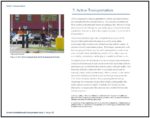
So our job—finding ways and making recommendations to make pedestrians (like the fellow in the picture, above!), bicyclists and transit users, as well as drivers, feel more comfortable along that corridor.

Are these survey results consistent with your view of that roadway?  Do you share the City’s future vision for the corridor as a neighborhood center—not place to be avoided but an attractive destination?

Transportation Funding: From Neutral Ground to Battleground

Visible damage to deck of I-35 in Duluth, MN


As I discussed in an earlier post, there’s a growing local and national backlog of critical transportation infrastructure projects—with no funding in sight.

Consensus Actually Exists

You might be interested to know that all branches of the federal government, from both sides of the isle, agree that we are not investing properly now for the transportation needs of the future.

To put this in perspective, the U.S. is spending approximately 4 to 5 times less on infrastructure than other countries are, including developing nations like China and India.

Since our interstate highway system was built in the 1960s, government expenditures on infrastructure have fallen to just 2.4 percent of GDP. In contrast Europe invests 5 percent of its GDP on infrastructure and China 9 percent.

Pothole as an example of transportation infrastructure that needs funding to maintainAs a result, the United States Is now ranked twenty-third overall for infrastructure quality, between Spain and Chile.

Political Will Does Not

Not so long ago, spending tax dollars on infrastructure was not nearly so political and divisive as it is today.  Roads, bridges and railways used to be neutral ground on which the parties could come together to support the country’s growth. In 1991, the federal transportation bill (the Intermodal Surface Transportation Efficiency Act, termed ISTEA for short), passed both branches of Congress by nearly a 5 to 1 margin.

Fast forward twenty years.

I-35 bridge collapse in Minneapolis, MN, Today’s gridlock in Washington has resulted in years of legislative limbo.  Transportation funding has been limping along under a series of short-term extensions and appropriations because Congress can’t agree on what should be included in the new transportation bill—and hasn’t figured out how to pay for them either.

The consequences of this inaction are severe. Crumbling bridges and roadways and increased congestion will not only be expensive problems to solve in the future, but will also have a cost in the increased amount of time we spend on substandard roads.

Our nation’s economic future relies on its ability to deliver goods and services, a task that is increasingly more difficult as our highway system falls into disrepair. Without action, our nation’s economic competitiveness will diminish.

While the urgency of the problem is plain to all – the political will to fix it isn’t there.

It Will Get Personal

And the hard part is, it’s not just our politicians who will need to make some attitude adjustments.  All of us, as users of the transportation network, will need to be willing to make a shift in how we think about paying our way.

Mileage-based fees, not motor fuel taxes, are the fairest way to assess the costs and benefits to the users of the system.  BUT…

Solutions Exist

There are many options, ideas and technologies available to us to pay for the transportation system we need, now and into the future.

But they will take some getting used to.  I’ll talk about them in my next blog post.  Stay tuned.

Pothole photo credit: David Erickson
 
 
I-35 photo credit: Marion Doss
 

Roads, Trails, or Both?

Priorities for Duluth’s Transportation System

As discussed in our previous blog, approximately $45 million in federal funds are being programmed for Duluth area transportation projects for 2012-2015.

The draft Transportation Improvement Program (TIP) spells out costs and timeframes for a total of 36 high-priority projects over four years and is now open for public comment.

Balancing the needs of all users

It seems we easily divide ourselves into those who drive versus those who ride the bus versus those who bike and so forth….an “us versus them” scenario.

Well, in reality the transportation system—and the public spaces they are a part of—are used by people in a much more complex way. You might drive to your job or to shop, but there will always be some amount of walking involved, from car to final destination and back again. You might use the sidewalks for walking from place to place, but also for stopping to talk to your neighbor in a common space. You might ride your bike down the big hill but put it on a DTA bus for the trip back up.

Looking through this lens, from the perspective of the users of the transportation system, you can see how this TIP has a major focus on how to really connect people in the safest and most efficient way possible. 

Continuing to fix the highways

Preservation work on the two major bridges is needed to refurbish the Blatnik (I-535) in 2012 and the Bong (US Highway 2) in 2014. These TIP projects not only have the highest price tags and but also will receive the most attention—yes, just when the I-35 reconstruction “megaproject” is finished, there will be several more years of high-profile road construction projects, on the bridges this time!

Improvements for those who walk, bike, or take the bus

While the highway projects are devoted solely to cars and trucks, funding is also included to provide a safe alternative to driving.  A paved pedestrian and bicycle pathway, running parallel to I-35, will connect the whole city from west  to east. The Munger Trail will eventually extend all the way to the Lakewalk by constructing short segments of a new Cross-City Trail each year. The popular Duluth Lakewalk will in turn be extended from 60th Avenue East to Highway 61, and then out to Brighton Beach up the north shore.

Funding for the Duluth Transit Authority will purchase new buses and provide operating support for both its regular route and STRIDE bus service.

And thanks to recent Complete Streets efforts in Duluth, local street projects will take into account how the roads are being used by people every day and will be designed accordingly.

The projects funded in the draft 2012-2015 Duluth area TIP balance the need to move vehicles efficiently with the needs of all people who use these public spaces, including those who utilize public transportation, those who traverse the roads by bicycle and those who are on foot.

Which makes sense to us – what do you think?